You are here: Home > Network List > TA - USArray Transportable Network (new EarthScope stations) Stations List
> Station J33A Davis, SD, USA > Earthquake Result Viewer
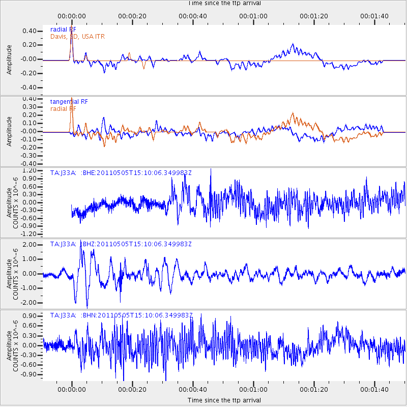
J33A Davis, SD, USA - Earthquake Result Viewer
*The percent match for this event was below the threshold and hence no stack was calculated.
| Earthquake location: |
Off East Coast Of Honshu, Japan |
| Earthquake latitude/longitude: |
38.2/144.0 |
| Earthquake time(UTC): |
2011/05/05 (125) 14:58:18 GMT |
| Earthquake Depth: |
11 km |
| Earthquake Magnitude: |
6.2 MB, 5.7 MS, 6.1 MW, 6.1 MW |
| Earthquake Catalog/Contributor: |
WHDF/NEIC |
|
| Network: |
TA USArray Transportable Network (new EarthScope stations) |
| Station: |
J33A Davis, SD, USA |
| Lat/Lon: |
43.32 N/96.97 W |
| Elevation: |
400 m |
|
| Distance: |
81.8 deg |
| Az: |
40.154 deg |
| Baz: |
315.861 deg |
| Ray Param: |
$rayparam |
*The percent match for this event was below the threshold and hence was not used in the summary stack. |
|
| Radial Match: |
49.495354 % |
| Radial Bump: |
400 |
| Transverse Match: |
62.54899 % |
| Transverse Bump: |
400 |
| SOD ConfigId: |
356183 |
| Insert Time: |
2011-10-06 15:04:00.534 +0000 |
| GWidth: |
2.5 |
| Max Bumps: |
400 |
| Tol: |
0.001 |
|
Signal To Noise
| Channel | StoN | STA | LTA |
| TA:J33A: :BHZ:20110505T15:10:06.349983Z | 8.591405 | 1.0763678E-6 | 1.2528426E-7 |
| TA:J33A: :BHN:20110505T15:10:06.349983Z | 2.161889 | 2.840656E-7 | 1.3139693E-7 |
| TA:J33A: :BHE:20110505T15:10:06.349983Z | 1.6280779 | 3.2859035E-7 | 2.0182716E-7 |
| Arrivals |
| Ps | |
| PpPs | |
| PsPs/PpSs | |


