You are here: Home > Network List > TA - USArray Transportable Network (new EarthScope stations) Stations List
> Station E32A Braaten, Kindred, ND, USA > Earthquake Result Viewer
E32A Braaten, Kindred, ND, USA - Earthquake Result Viewer
| Earthquake location: |
Off East Coast Of Honshu, Japan |
| Earthquake latitude/longitude: |
38.2/144.0 |
| Earthquake time(UTC): |
2011/05/05 (125) 14:58:18 GMT |
| Earthquake Depth: |
11 km |
| Earthquake Magnitude: |
6.2 MB, 5.7 MS, 6.1 MW, 6.1 MW |
| Earthquake Catalog/Contributor: |
WHDF/NEIC |
|
| Network: |
TA USArray Transportable Network (new EarthScope stations) |
| Station: |
E32A Braaten, Kindred, ND, USA |
| Lat/Lon: |
46.59 N/97.07 W |
| Elevation: |
297 m |
|
| Distance: |
79.5 deg |
| Az: |
37.888 deg |
| Baz: |
315.42 deg |
| Ray Param: |
0.0489475 |
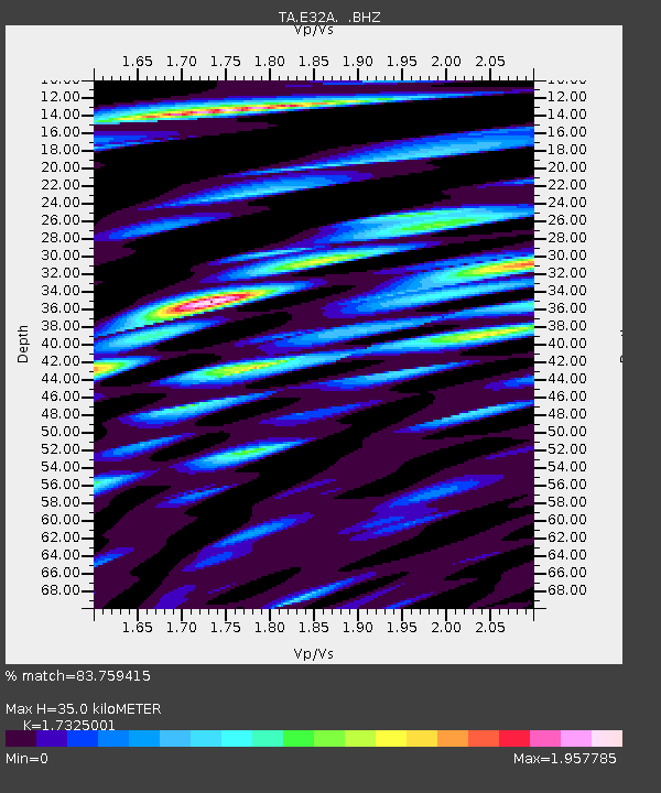
| Estimated Moho Depth: |
35.0 km |
| Estimated Crust Vp/Vs: |
1.73 |
| Assumed Crust Vp: |
6.498 km/s |
| Estimated Crust Vs: |
3.75 km/s |
| Estimated Crust Poisson's Ratio: |
0.25 |
|
| Radial Match: |
83.759415 % |
| Radial Bump: |
400 |
| Transverse Match: |
65.45299 % |
| Transverse Bump: |
400 |
| SOD ConfigId: |
356183 |
| Insert Time: |
2011-10-06 15:08:30.717 +0000 |
| GWidth: |
2.5 |
| Max Bumps: |
400 |
| Tol: |
0.001 |
|
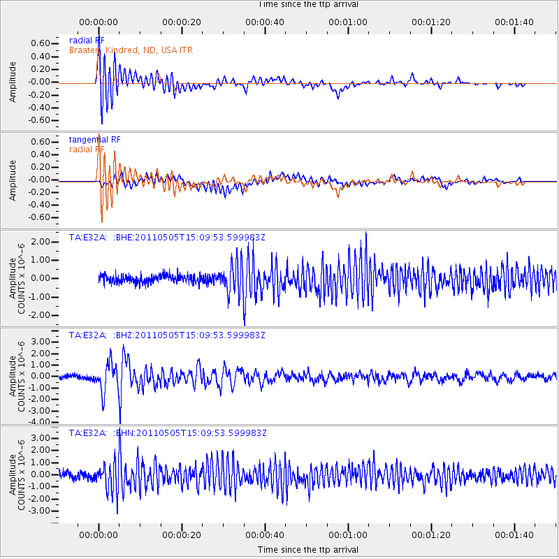
Signal To Noise
| Channel | StoN | STA | LTA |
| TA:E32A: :BHZ:20110505T15:09:53.599983Z | 6.884159 | 1.2756598E-6 | 1.8530365E-7 |
| TA:E32A: :BHN:20110505T15:09:53.599983Z | 4.966048 | 1.1812325E-6 | 2.378617E-7 |
| TA:E32A: :BHE:20110505T15:09:53.599983Z | 4.0183277 | 8.013798E-7 | 1.9943118E-7 |
| Arrivals |
| Ps | 4.1 SECOND |
| PpPs | 14 SECOND |
| PsPs/PpSs | 18 SECOND |


