You are here: Home > Network List > TA - USArray Transportable Network (new EarthScope stations) Stations List
> Station D31A Mcclaflin, Tower City, ND, USA > Earthquake Result Viewer
D31A Mcclaflin, Tower City, ND, USA - Earthquake Result Viewer
| Earthquake location: |
Off East Coast Of Honshu, Japan |
| Earthquake latitude/longitude: |
38.2/144.0 |
| Earthquake time(UTC): |
2011/05/05 (125) 14:58:18 GMT |
| Earthquake Depth: |
11 km |
| Earthquake Magnitude: |
6.2 MB, 5.7 MS, 6.1 MW, 6.1 MW |
| Earthquake Catalog/Contributor: |
WHDF/NEIC |
|
| Network: |
TA USArray Transportable Network (new EarthScope stations) |
| Station: |
D31A Mcclaflin, Tower City, ND, USA |
| Lat/Lon: |
47.05 N/97.72 W |
| Elevation: |
359 m |
|
| Distance: |
78.8 deg |
| Az: |
37.884 deg |
| Baz: |
314.945 deg |
| Ray Param: |
0.0493835 |
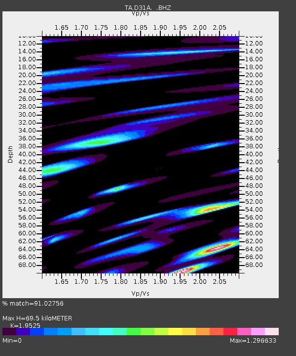
| Estimated Moho Depth: |
69.5 km |
| Estimated Crust Vp/Vs: |
1.95 |
| Assumed Crust Vp: |
6.498 km/s |
| Estimated Crust Vs: |
3.328 km/s |
| Estimated Crust Poisson's Ratio: |
0.32 |
|
| Radial Match: |
91.02756 % |
| Radial Bump: |
400 |
| Transverse Match: |
56.49208 % |
| Transverse Bump: |
400 |
| SOD ConfigId: |
356183 |
| Insert Time: |
2011-10-06 15:08:49.149 +0000 |
| GWidth: |
2.5 |
| Max Bumps: |
400 |
| Tol: |
0.001 |
|

Signal To Noise
| Channel | StoN | STA | LTA |
| TA:D31A: :BHZ:20110505T15:09:50.099983Z | 4.707432 | 1.3552495E-6 | 2.8789572E-7 |
| TA:D31A: :BHN:20110505T15:09:50.099983Z | 1.7089101 | 5.0233996E-7 | 2.939534E-7 |
| TA:D31A: :BHE:20110505T15:09:50.099983Z | 1.4853855 | 5.54631E-7 | 3.7339197E-7 |
| Arrivals |
| Ps | 10 SECOND |
| PpPs | 31 SECOND |
| PsPs/PpSs | 41 SECOND |


