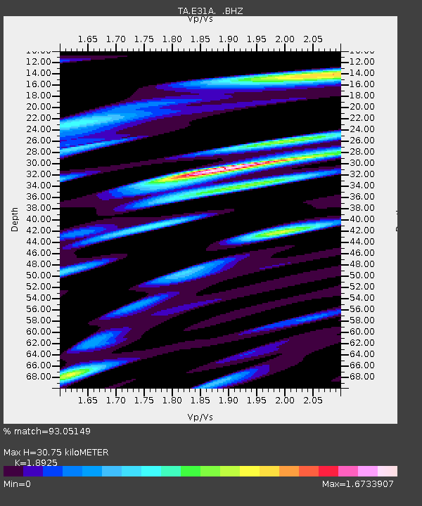
E31A Nome, ND, USA - Earthquake Result Viewer
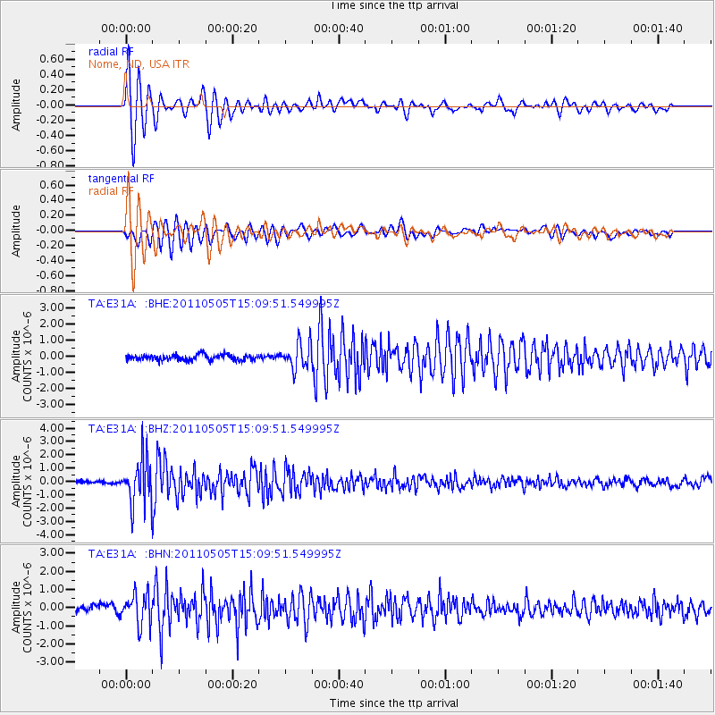
Earthquake location: Off East Coast Of Honshu, Japan
Earthquake latitude/longitude: 38.2/144.0
Earthquake time(UTC): 2011/05/05 (125) 14:58:18 GMT
Earthquake Depth: 11 km
Earthquake Magnitude: 6.2 MB, 5.7 MS, 6.1 MW, 6.1 MW
Earthquake Catalog/Contributor: WHDF/NEIC
Network: TA USArray Transportable Network (new EarthScope stations)
Station: E31A Nome, ND, USA
Lat/Lon: 46.56 N/97.89 W
Elevation: 427 m
Distance: 79.1 deg
Az: 38.32 deg
Baz: 314.909 deg
Ray Param: 0.049203426
Estimated Moho Depth: 30.75 km
Estimated Crust Vp/Vs: 1.89
Assumed Crust Vp: 6.498 km/s
Estimated Crust Vs: 3.433 km/s
Estimated Crust Poisson's Ratio: 0.31
Radial Match: 93.05149 %
Radial Bump: 400
Transverse Match: 87.58184 %
Transverse Bump: 400
SOD ConfigId: 356183
Insert Time: 2011-10-06 15:11:24.663 +0000
GWidth: 2.5
Max Bumps: 400
Tol: 0.001

Signal To Noise

ChannelStoNSTALTA
TA:E31A: :BHZ:20110505T15:09:51.549995Z11.2406081.7217392E-61.5317136E-7
TA:E31A: :BHN:20110505T15:09:51.549995Z3.9210218.6330334E-72.2017309E-7
TA:E31A: :BHE:20110505T15:09:51.549995Z4.7992428.306512E-71.7307967E-7
Arrivals
Ps4.3 SECOND
PpPs13 SECOND
PsPs/PpSs18 SECOND