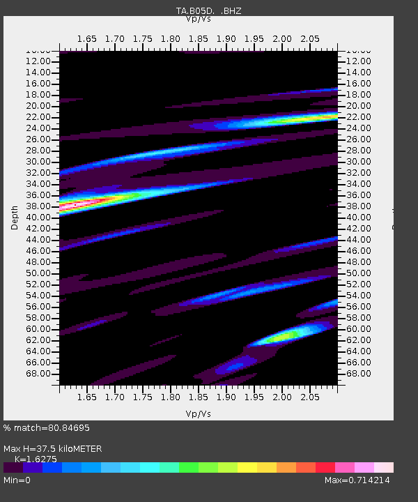
B05D Stanwood, WA, USA - Earthquake Result Viewer

Earthquake location: Off East Coast Of Honshu, Japan
Earthquake latitude/longitude: 38.2/144.0
Earthquake time(UTC): 2011/05/05 (125) 14:58:18 GMT
Earthquake Depth: 11 km
Earthquake Magnitude: 6.2 MB, 5.7 MS, 6.1 MW, 6.1 MW
Earthquake Catalog/Contributor: WHDF/NEIC
Network: TA USArray Transportable Network (new EarthScope stations)
Station: B05D Stanwood, WA, USA
Lat/Lon: 48.26 N/122.10 W
Elevation: 153 m
Distance: 65.0 deg
Az: 47.346 deg
Baz: 299.825 deg
Ray Param: 0.058544714
Estimated Moho Depth: 37.5 km
Estimated Crust Vp/Vs: 1.63
Assumed Crust Vp: 6.566 km/s
Estimated Crust Vs: 4.035 km/s
Estimated Crust Poisson's Ratio: 0.20
Radial Match: 80.84695 %
Radial Bump: 400
Transverse Match: 75.47832 %
Transverse Bump: 400
SOD ConfigId: 356183
Insert Time: 2011-10-06 15:14:41.018 +0000
GWidth: 2.5
Max Bumps: 400
Tol: 0.001

Signal To Noise

ChannelStoNSTALTA
TA:B05D: :BHZ:20110505T15:08:27.549995Z4.1794368.664151E-72.0730431E-7
TA:B05D: :BHN:20110505T15:08:27.549995Z2.0120822.8650985E-71.4239473E-7
TA:B05D: :BHE:20110505T15:08:27.549995Z1.53343183.101657E-72.0226899E-7
Arrivals
Ps3.8 SECOND
PpPs14 SECOND
PsPs/PpSs18 SECOND