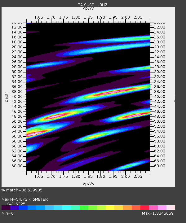
SUSD Miller, SD, USA - Earthquake Result Viewer

Earthquake location: Off East Coast Of Honshu, Japan
Earthquake latitude/longitude: 38.2/144.0
Earthquake time(UTC): 2011/05/05 (125) 14:58:18 GMT
Earthquake Depth: 11 km
Earthquake Magnitude: 6.2 MB, 5.7 MS, 6.1 MW, 6.1 MW
Earthquake Catalog/Contributor: WHDF/NEIC
Network: TA USArray Transportable Network (new EarthScope stations)
Station: SUSD Miller, SD, USA
Lat/Lon: 44.44 N/98.96 W
Elevation: 520 m
Distance: 80.0 deg
Az: 40.385 deg
Baz: 314.524 deg
Ray Param: 0.048549242
Estimated Moho Depth: 54.75 km
Estimated Crust Vp/Vs: 1.63
Assumed Crust Vp: 6.53 km/s
Estimated Crust Vs: 4.0 km/s
Estimated Crust Poisson's Ratio: 0.20
Radial Match: 86.519905 %
Radial Bump: 400
Transverse Match: 74.57625 %
Transverse Bump: 400
SOD ConfigId: 356183
Insert Time: 2011-10-06 15:15:03.445 +0000
GWidth: 2.5
Max Bumps: 400
Tol: 0.001

Signal To Noise

ChannelStoNSTALTA
TA:SUSD: :BHZ:20110505T15:09:56.724983Z8.8097871.3900851E-61.5778873E-7
TA:SUSD: :BHN:20110505T15:09:56.724983Z3.70894627.876561E-72.1236656E-7
TA:SUSD: :BHE:20110505T15:09:56.724983Z3.52086458.0210754E-72.278155E-7
Arrivals
Ps5.5 SECOND
PpPs21 SECOND
PsPs/PpSs27 SECOND