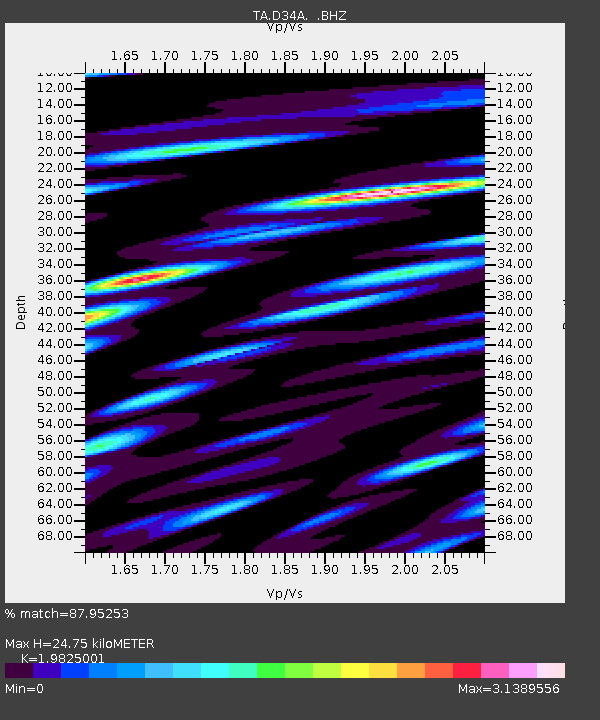
D34A Park Rapids, MN, USA - Earthquake Result Viewer

Earthquake location: Off East Coast Of Honshu, Japan
Earthquake latitude/longitude: 38.2/144.0
Earthquake time(UTC): 2011/05/05 (125) 14:58:18 GMT
Earthquake Depth: 11 km
Earthquake Magnitude: 6.2 MB, 5.7 MS, 6.1 MW, 6.1 MW
Earthquake Catalog/Contributor: WHDF/NEIC
Network: TA USArray Transportable Network (new EarthScope stations)
Station: D34A Park Rapids, MN, USA
Lat/Lon: 47.09 N/95.20 W
Elevation: 476 m
Distance: 80.0 deg
Az: 36.599 deg
Baz: 316.554 deg
Ray Param: 0.04857763
Estimated Moho Depth: 24.75 km
Estimated Crust Vp/Vs: 1.98
Assumed Crust Vp: 6.419 km/s
Estimated Crust Vs: 3.238 km/s
Estimated Crust Poisson's Ratio: 0.33
Radial Match: 87.95253 %
Radial Bump: 400
Transverse Match: 68.99748 %
Transverse Bump: 400
SOD ConfigId: 356183
Insert Time: 2011-10-06 15:16:36.310 +0000
GWidth: 2.5
Max Bumps: 400
Tol: 0.001

Signal To Noise

ChannelStoNSTALTA
TA:D34A: :BHZ:20110505T15:09:56.500007Z8.5318831.2456953E-61.4600474E-7
TA:D34A: :BHN:20110505T15:09:56.500007Z3.40882686.145196E-71.8027305E-7
TA:D34A: :BHE:20110505T15:09:56.500007Z3.40799675.443639E-71.5973134E-7
Arrivals
Ps3.9 SECOND
PpPs11 SECOND
PsPs/PpSs15 SECOND