You are here: Home > Network List > TA - USArray Transportable Network (new EarthScope stations) Stations List
> Station C33A Trail, MN, USA > Earthquake Result Viewer
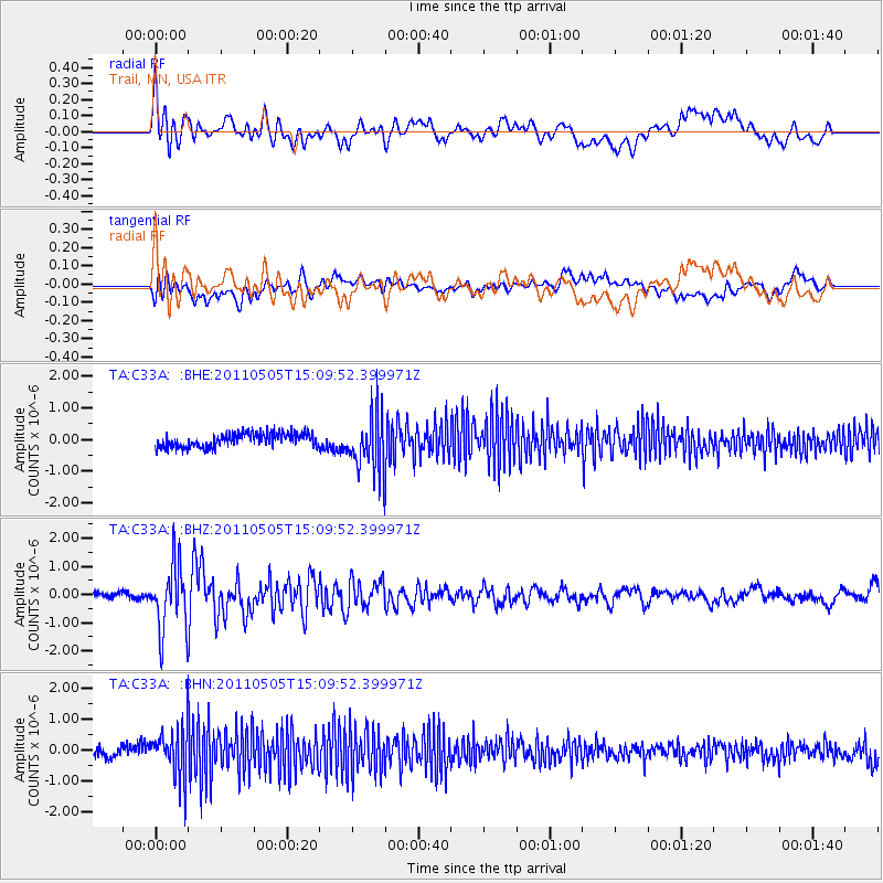
C33A Trail, MN, USA - Earthquake Result Viewer
*The percent match for this event was below the threshold and hence no stack was calculated.
| Earthquake location: |
Off East Coast Of Honshu, Japan |
| Earthquake latitude/longitude: |
38.2/144.0 |
| Earthquake time(UTC): |
2011/05/05 (125) 14:58:18 GMT |
| Earthquake Depth: |
11 km |
| Earthquake Magnitude: |
6.2 MB, 5.7 MS, 6.1 MW, 6.1 MW |
| Earthquake Catalog/Contributor: |
WHDF/NEIC |
|
| Network: |
TA USArray Transportable Network (new EarthScope stations) |
| Station: |
C33A Trail, MN, USA |
| Lat/Lon: |
47.76 N/95.77 W |
| Elevation: |
388 m |
|
| Distance: |
79.2 deg |
| Az: |
36.414 deg |
| Baz: |
316.097 deg |
| Ray Param: |
$rayparam |
*The percent match for this event was below the threshold and hence was not used in the summary stack. |
|
| Radial Match: |
64.79475 % |
| Radial Bump: |
400 |
| Transverse Match: |
59.297997 % |
| Transverse Bump: |
400 |
| SOD ConfigId: |
356183 |
| Insert Time: |
2011-10-06 15:16:38.980 +0000 |
| GWidth: |
2.5 |
| Max Bumps: |
400 |
| Tol: |
0.001 |
|
Signal To Noise
| Channel | StoN | STA | LTA |
| TA:C33A: :BHZ:20110505T15:09:52.399971Z | 11.813087 | 1.1726853E-6 | 9.927001E-8 |
| TA:C33A: :BHN:20110505T15:09:52.399971Z | 3.793654 | 7.9891316E-7 | 2.1059199E-7 |
| TA:C33A: :BHE:20110505T15:09:52.399971Z | 4.260525 | 9.305637E-7 | 2.1841525E-7 |
| Arrivals |
| Ps | |
| PpPs | |
| PsPs/PpSs | |


