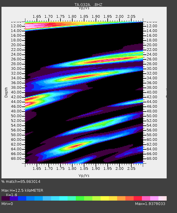
G32A Webster, SD, USA - Earthquake Result Viewer
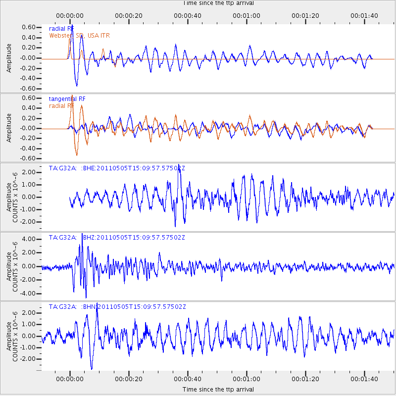
Earthquake location: Off East Coast Of Honshu, Japan
Earthquake latitude/longitude: 38.2/144.0
Earthquake time(UTC): 2011/05/05 (125) 14:58:18 GMT
Earthquake Depth: 11 km
Earthquake Magnitude: 6.2 MB, 5.7 MS, 6.1 MW, 6.1 MW
Earthquake Catalog/Contributor: WHDF/NEIC
Network: TA USArray Transportable Network (new EarthScope stations)
Station: G32A Webster, SD, USA
Lat/Lon: 45.26 N/97.50 W
Elevation: 566 m
Distance: 80.2 deg
Az: 39.059 deg
Baz: 315.32 deg
Ray Param: 0.04844002
Estimated Moho Depth: 12.5 km
Estimated Crust Vp/Vs: 1.60
Assumed Crust Vp: 6.552 km/s
Estimated Crust Vs: 4.095 km/s
Estimated Crust Poisson's Ratio: 0.18
Radial Match: 85.863014 %
Radial Bump: 400
Transverse Match: 63.45957 %
Transverse Bump: 400
SOD ConfigId: 356183
Insert Time: 2011-10-06 15:19:36.286 +0000
GWidth: 2.5
Max Bumps: 400
Tol: 0.001

Signal To Noise

ChannelStoNSTALTA
TA:G32A: :BHZ:20110505T15:09:57.57502Z9.21707251.8365826E-61.9925878E-7
TA:G32A: :BHN:20110505T15:09:57.57502Z2.2179327.7563107E-73.4970913E-7
TA:G32A: :BHE:20110505T15:09:57.57502Z1.4851217.197735E-74.846565E-7
Arrivals
Ps1.2 SECOND
PpPs4.8 SECOND
PsPs/PpSs6.0 SECOND