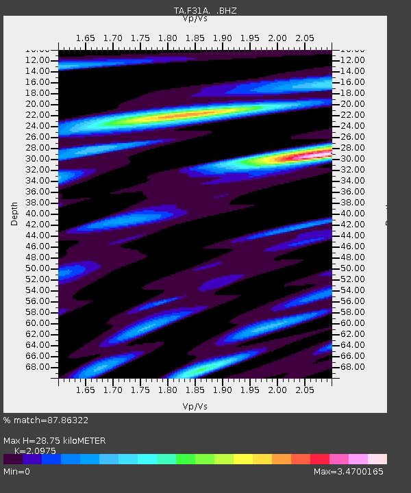
F31A Hecla, SD, USA - Earthquake Result Viewer
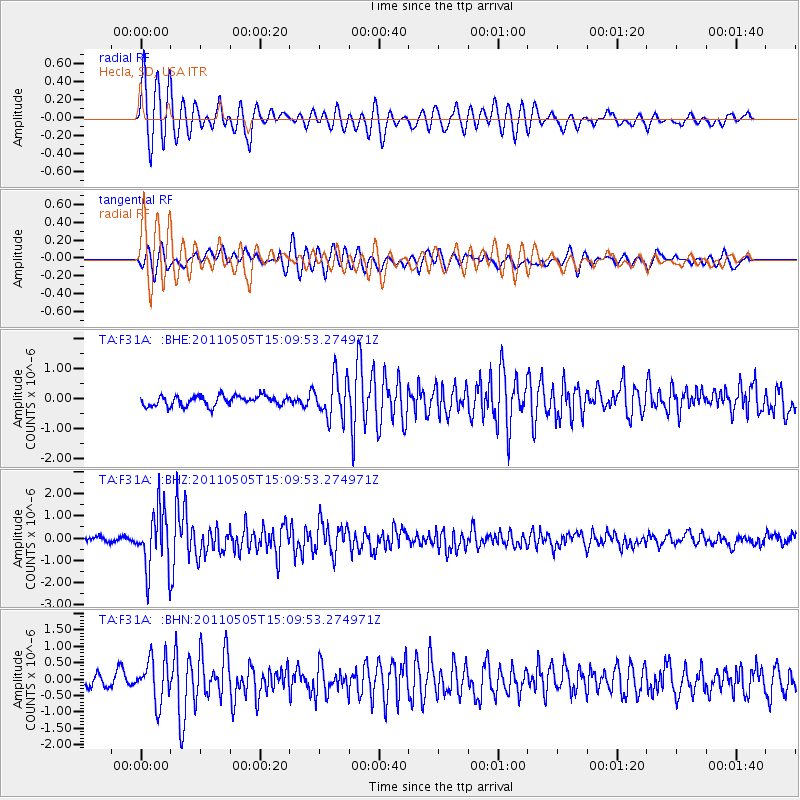
Earthquake location: Off East Coast Of Honshu, Japan
Earthquake latitude/longitude: 38.2/144.0
Earthquake time(UTC): 2011/05/05 (125) 14:58:18 GMT
Earthquake Depth: 11 km
Earthquake Magnitude: 6.2 MB, 5.7 MS, 6.1 MW, 6.1 MW
Earthquake Catalog/Contributor: WHDF/NEIC
Network: TA USArray Transportable Network (new EarthScope stations)
Station: F31A Hecla, SD, USA
Lat/Lon: 45.86 N/98.25 W
Elevation: 412 m
Distance: 79.4 deg
Az: 39.006 deg
Baz: 314.774 deg
Ray Param: 0.04898878
Estimated Moho Depth: 28.75 km
Estimated Crust Vp/Vs: 2.10
Assumed Crust Vp: 6.53 km/s
Estimated Crust Vs: 3.113 km/s
Estimated Crust Poisson's Ratio: 0.35
Radial Match: 87.86322 %
Radial Bump: 400
Transverse Match: 82.05768 %
Transverse Bump: 400
SOD ConfigId: 356183
Insert Time: 2011-10-06 15:20:33.006 +0000
GWidth: 2.5
Max Bumps: 400
Tol: 0.001

Signal To Noise

ChannelStoNSTALTA
TA:F31A: :BHZ:20110505T15:09:53.274971Z12.4685631.3522297E-61.08451125E-7
TA:F31A: :BHN:20110505T15:09:53.274971Z3.04989556.5864805E-72.1595758E-7
TA:F31A: :BHE:20110505T15:09:53.274971Z4.0191266.839099E-71.7016383E-7
Arrivals
Ps5.0 SECOND
PpPs13 SECOND
PsPs/PpSs18 SECOND