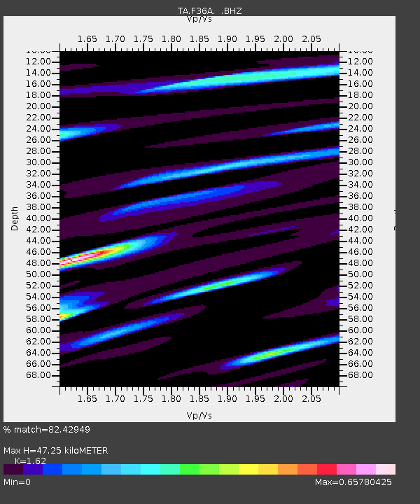
F36A Milaca, MN, USA - Earthquake Result Viewer

Earthquake location: Off East Coast Of Honshu, Japan
Earthquake latitude/longitude: 38.2/144.0
Earthquake time(UTC): 2011/05/05 (125) 14:58:18 GMT
Earthquake Depth: 11 km
Earthquake Magnitude: 6.2 MB, 5.7 MS, 6.1 MW, 6.1 MW
Earthquake Catalog/Contributor: WHDF/NEIC
Network: TA USArray Transportable Network (new EarthScope stations)
Station: F36A Milaca, MN, USA
Lat/Lon: 45.86 N/93.52 W
Elevation: 345 m
Distance: 81.7 deg
Az: 36.584 deg
Baz: 317.759 deg
Ray Param: 0.047416613
Estimated Moho Depth: 47.25 km
Estimated Crust Vp/Vs: 1.62
Assumed Crust Vp: 6.571 km/s
Estimated Crust Vs: 4.056 km/s
Estimated Crust Poisson's Ratio: 0.19
Radial Match: 82.42949 %
Radial Bump: 400
Transverse Match: 59.491665 %
Transverse Bump: 400
SOD ConfigId: 356183
Insert Time: 2011-10-06 15:21:38.528 +0000
GWidth: 2.5
Max Bumps: 400
Tol: 0.001

Signal To Noise

ChannelStoNSTALTA
TA:F36A: :BHZ:20110505T15:10:05.45002Z6.646827.341224E-71.1044716E-7
TA:F36A: :BHN:20110505T15:10:05.45002Z2.39845682.594668E-71.0818073E-7
TA:F36A: :BHE:20110505T15:10:05.45002Z2.8230822.3707346E-78.397682E-8
Arrivals
Ps4.6 SECOND
PpPs18 SECOND
PsPs/PpSs23 SECOND