You are here: Home > Network List > TA - USArray Transportable Network (new EarthScope stations) Stations List
> Station B35A Bob, Littlefork, MN, USA > Earthquake Result Viewer
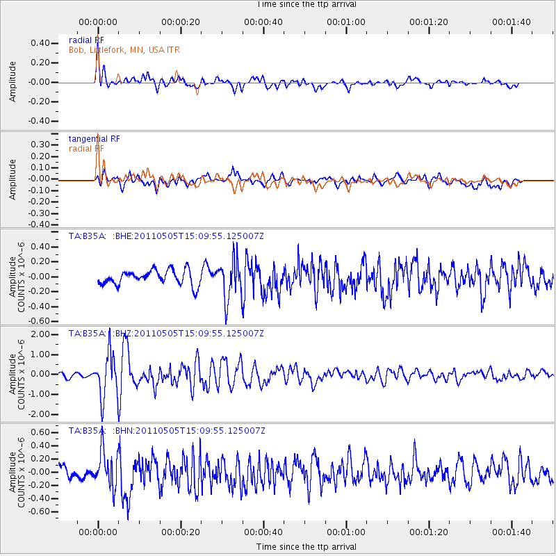
B35A Bob, Littlefork, MN, USA - Earthquake Result Viewer
*The percent match for this event was below the threshold and hence no stack was calculated.
| Earthquake location: |
Off East Coast Of Honshu, Japan |
| Earthquake latitude/longitude: |
38.2/144.0 |
| Earthquake time(UTC): |
2011/05/05 (125) 14:58:18 GMT |
| Earthquake Depth: |
11 km |
| Earthquake Magnitude: |
6.2 MB, 5.7 MS, 6.1 MW, 6.1 MW |
| Earthquake Catalog/Contributor: |
WHDF/NEIC |
|
| Network: |
TA USArray Transportable Network (new EarthScope stations) |
| Station: |
B35A Bob, Littlefork, MN, USA |
| Lat/Lon: |
48.36 N/93.73 W |
| Elevation: |
358 m |
|
| Distance: |
79.7 deg |
| Az: |
34.978 deg |
| Baz: |
317.352 deg |
| Ray Param: |
$rayparam |
*The percent match for this event was below the threshold and hence was not used in the summary stack. |
|
| Radial Match: |
74.71001 % |
| Radial Bump: |
400 |
| Transverse Match: |
64.44201 % |
| Transverse Bump: |
400 |
| SOD ConfigId: |
356183 |
| Insert Time: |
2011-10-06 15:30:52.977 +0000 |
| GWidth: |
2.5 |
| Max Bumps: |
400 |
| Tol: |
0.001 |
|
Signal To Noise
| Channel | StoN | STA | LTA |
| TA:B35A: :BHZ:20110505T15:09:55.125007Z | 11.041275 | 1.1310723E-6 | 1.02440374E-7 |
| TA:B35A: :BHN:20110505T15:09:55.125007Z | 2.8020728 | 2.829366E-7 | 1.0097404E-7 |
| TA:B35A: :BHE:20110505T15:09:55.125007Z | 2.7799113 | 2.722925E-7 | 9.795007E-8 |
| Arrivals |
| Ps | |
| PpPs | |
| PsPs/PpSs | |


