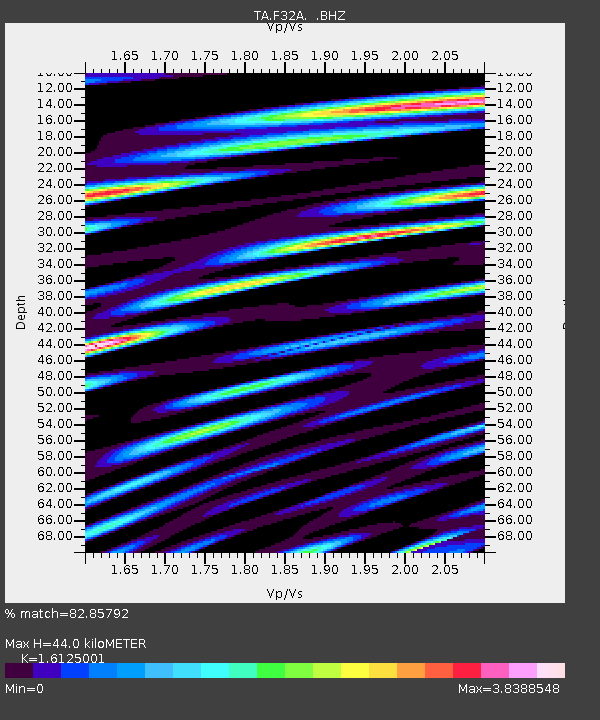
F32A Veblen, SD, USA - Earthquake Result Viewer
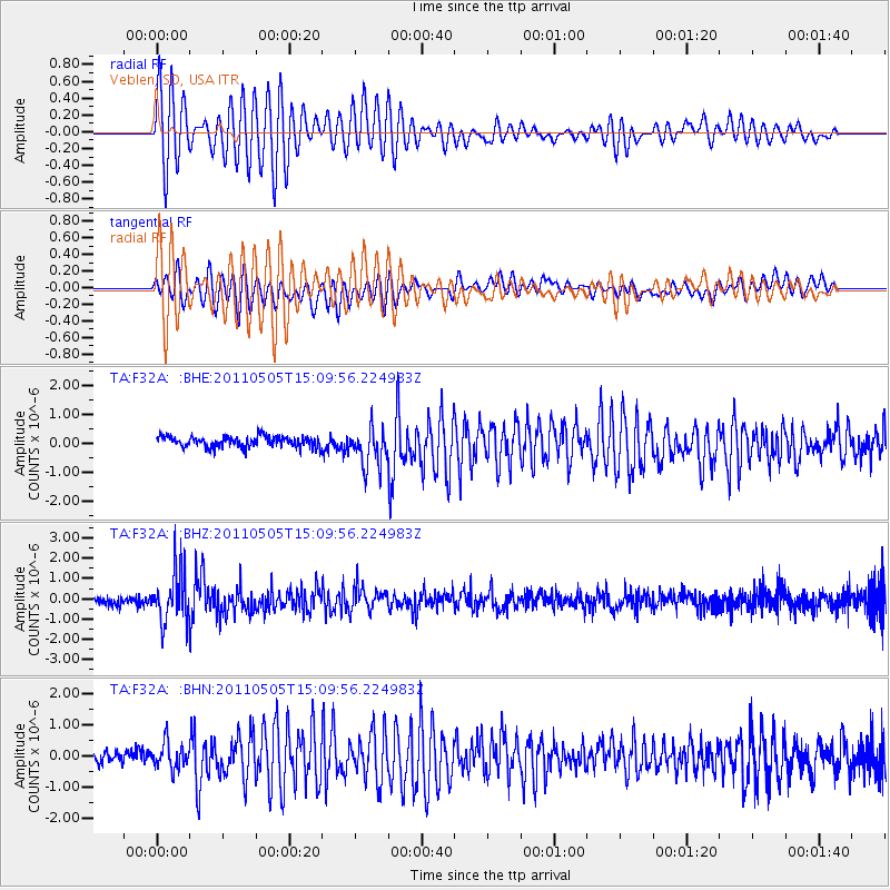
Earthquake location: Off East Coast Of Honshu, Japan
Earthquake latitude/longitude: 38.2/144.0
Earthquake time(UTC): 2011/05/05 (125) 14:58:18 GMT
Earthquake Depth: 11 km
Earthquake Magnitude: 6.2 MB, 5.7 MS, 6.1 MW, 6.1 MW
Earthquake Catalog/Contributor: WHDF/NEIC
Network: TA USArray Transportable Network (new EarthScope stations)
Station: F32A Veblen, SD, USA
Lat/Lon: 45.87 N/97.13 W
Elevation: 371 m
Distance: 79.9 deg
Az: 38.431 deg
Baz: 315.477 deg
Ray Param: 0.048613675
Estimated Moho Depth: 44.0 km
Estimated Crust Vp/Vs: 1.61
Assumed Crust Vp: 6.552 km/s
Estimated Crust Vs: 4.064 km/s
Estimated Crust Poisson's Ratio: 0.19
Radial Match: 82.85792 %
Radial Bump: 400
Transverse Match: 63.83911 %
Transverse Bump: 400
SOD ConfigId: 356183
Insert Time: 2011-10-06 15:33:28.188 +0000
GWidth: 2.5
Max Bumps: 400
Tol: 0.001

Signal To Noise

ChannelStoNSTALTA
TA:F32A: :BHZ:20110505T15:09:56.224983Z6.69488431.269603E-61.8963779E-7
TA:F32A: :BHN:20110505T15:09:56.224983Z1.42888134.1863194E-72.929788E-7
TA:F32A: :BHE:20110505T15:09:56.224983Z3.63304046.779348E-71.8660259E-7
Arrivals
Ps4.2 SECOND
PpPs17 SECOND
PsPs/PpSs21 SECOND