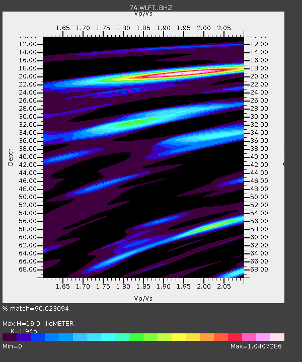
WLFT Gordonsville, Virginia USA - Earthquake Result Viewer

Earthquake location: Near Coast Of Northern Peru
Earthquake latitude/longitude: -5.6/-81.0
Earthquake time(UTC): 2014/03/15 (074) 23:51:33 GMT
Earthquake Depth: 29 km
Earthquake Magnitude: 6.3 MWW, 6.2 MWB, 6.3 MWC
Earthquake Catalog/Contributor: NEIC PDE/NEIC COMCAT
Network: 7A Mid-Atlantic Geophysical Integrative Collaboration
Station: WLFT Gordonsville, Virginia USA
Lat/Lon: 38.17 N/78.14 W
Elevation: 110 m
Distance: 43.6 deg
Az: 3.215 deg
Baz: 184.061 deg
Ray Param: 0.07239177
Estimated Moho Depth: 19.0 km
Estimated Crust Vp/Vs: 1.95
Assumed Crust Vp: 6.159 km/s
Estimated Crust Vs: 3.166 km/s
Estimated Crust Poisson's Ratio: 0.32
Radial Match: 90.023094 %
Radial Bump: 364
Transverse Match: 74.16353 %
Transverse Bump: 400
SOD ConfigId: 3390531
Insert Time: 2019-04-10 16:39:48.115 +0000
GWidth: 2.5
Max Bumps: 400
Tol: 0.001

Signal To Noise

ChannelStoNSTALTA
7A:WLFT: :BHZ:20140315T23:59:04.200004Z5.2935331.0280817E-61.9421465E-7
7A:WLFT: :BHN:20140315T23:59:04.200004Z3.51747375.531171E-71.5724841E-7
7A:WLFT: :BHE:20140315T23:59:04.200004Z1.06999531.3772761E-71.2871796E-7
Arrivals
Ps3.1 SECOND
PpPs8.6 SECOND
PsPs/PpSs12 SECOND