You are here: Home > Network List > TA - USArray Transportable Network (new EarthScope stations) Stations List
> Station 147A Livingston, AL, USA > Earthquake Result Viewer
147A Livingston, AL, USA - Earthquake Result Viewer
*The percent match for this event was below the threshold and hence no stack was calculated.
| Earthquake location: |
Off East Coast Of Honshu, Japan |
| Earthquake latitude/longitude: |
38.2/144.0 |
| Earthquake time(UTC): |
2011/05/05 (125) 14:58:18 GMT |
| Earthquake Depth: |
11 km |
| Earthquake Magnitude: |
6.2 MB, 5.7 MS, 6.1 MW, 6.1 MW |
| Earthquake Catalog/Contributor: |
WHDF/NEIC |
|
| Network: |
TA USArray Transportable Network (new EarthScope stations) |
| Station: |
147A Livingston, AL, USA |
| Lat/Lon: |
32.67 N/88.27 W |
| Elevation: |
57 m |
|
| Distance: |
94.3 deg |
| Az: |
42.011 deg |
| Baz: |
321.284 deg |
| Ray Param: |
$rayparam |
*The percent match for this event was below the threshold and hence was not used in the summary stack. |
|
| Radial Match: |
49.851364 % |
| Radial Bump: |
400 |
| Transverse Match: |
51.78233 % |
| Transverse Bump: |
400 |
| SOD ConfigId: |
356183 |
| Insert Time: |
2011-10-06 15:53:08.254 +0000 |
| GWidth: |
2.5 |
| Max Bumps: |
400 |
| Tol: |
0.001 |
|
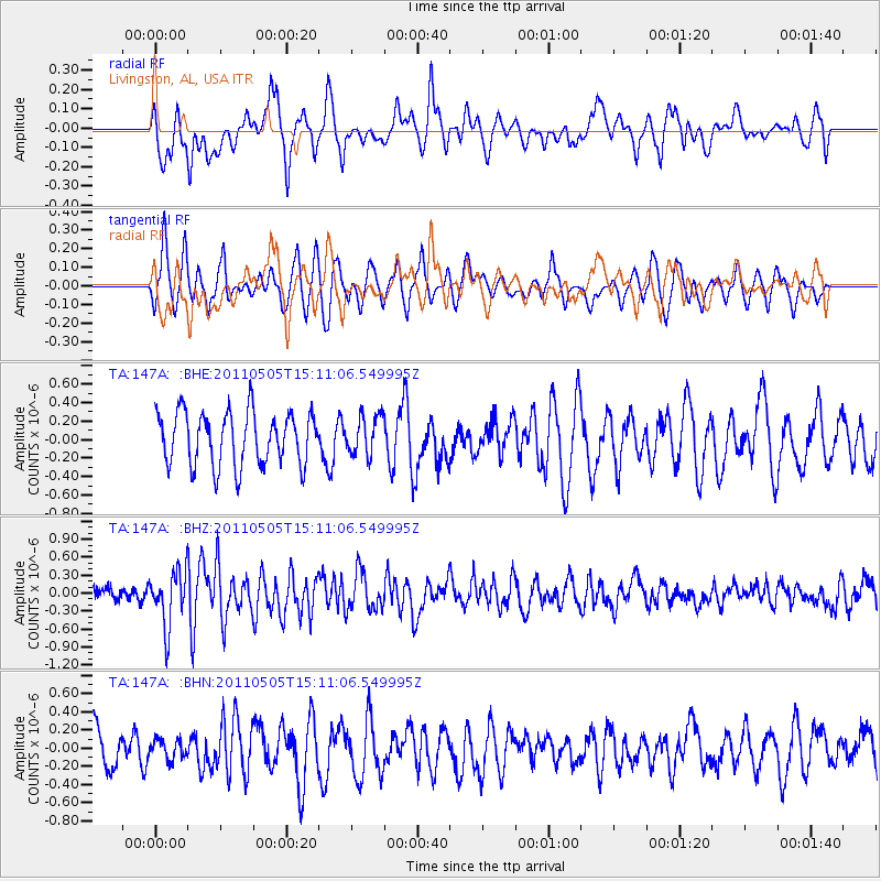
Signal To Noise
| Channel | StoN | STA | LTA |
| TA:147A: :BHZ:20110505T15:11:06.549995Z | 3.450493 | 4.5248433E-7 | 1.3113613E-7 |
| TA:147A: :BHN:20110505T15:11:06.549995Z | 0.3785977 | 1.05900334E-7 | 2.797173E-7 |
| TA:147A: :BHE:20110505T15:11:06.549995Z | 0.7407196 | 2.1401125E-7 | 2.8892342E-7 |
| Arrivals |
| Ps | |
| PpPs | |
| PsPs/PpSs | |


