You are here: Home > Network List > TA - USArray Transportable Network (new EarthScope stations) Stations List
> Station Z47A Carrollton, AL, USA > Earthquake Result Viewer
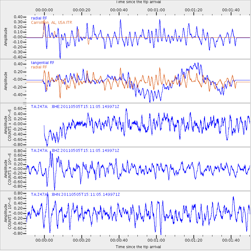
Z47A Carrollton, AL, USA - Earthquake Result Viewer
*The percent match for this event was below the threshold and hence no stack was calculated.
| Earthquake location: |
Off East Coast Of Honshu, Japan |
| Earthquake latitude/longitude: |
38.2/144.0 |
| Earthquake time(UTC): |
2011/05/05 (125) 14:58:18 GMT |
| Earthquake Depth: |
11 km |
| Earthquake Magnitude: |
6.2 MB, 5.7 MS, 6.1 MW, 6.1 MW |
| Earthquake Catalog/Contributor: |
WHDF/NEIC |
|
| Network: |
TA USArray Transportable Network (new EarthScope stations) |
| Station: |
Z47A Carrollton, AL, USA |
| Lat/Lon: |
33.20 N/88.07 W |
| Elevation: |
65 m |
|
| Distance: |
94.0 deg |
| Az: |
41.55 deg |
| Baz: |
321.427 deg |
| Ray Param: |
$rayparam |
*The percent match for this event was below the threshold and hence was not used in the summary stack. |
|
| Radial Match: |
58.635757 % |
| Radial Bump: |
400 |
| Transverse Match: |
48.735966 % |
| Transverse Bump: |
400 |
| SOD ConfigId: |
356183 |
| Insert Time: |
2011-10-06 15:54:45.648 +0000 |
| GWidth: |
2.5 |
| Max Bumps: |
400 |
| Tol: |
0.001 |
|
Signal To Noise
| Channel | StoN | STA | LTA |
| TA:Z47A: :BHZ:20110505T15:11:05.149971Z | 2.8989458 | 4.1075575E-7 | 1.4169142E-7 |
| TA:Z47A: :BHN:20110505T15:11:05.149971Z | 1.7028534 | 4.3327162E-7 | 2.544386E-7 |
| TA:Z47A: :BHE:20110505T15:11:05.149971Z | 0.95130587 | 2.6771414E-7 | 2.8141753E-7 |
| Arrivals |
| Ps | |
| PpPs | |
| PsPs/PpSs | |


