You are here: Home > Network List > PB - Plate Boundary Observatory Borehole Seismic Network Stations List
> Station B088A skyoks088bcs2007, Anza, CA, USA > Earthquake Result Viewer
B088A skyoks088bcs2007, Anza, CA, USA - Earthquake Result Viewer
| Earthquake location: |
Near Coast Of Northern Peru |
| Earthquake latitude/longitude: |
-5.6/-81.0 |
| Earthquake time(UTC): |
2014/03/15 (074) 23:51:33 GMT |
| Earthquake Depth: |
29 km |
| Earthquake Magnitude: |
6.3 MWW, 6.2 MWB, 6.3 MWC |
| Earthquake Catalog/Contributor: |
NEIC PDE/NEIC COMCAT |
|
| Network: |
PB Plate Boundary Observatory Borehole Seismic Network |
| Station: |
B088A skyoks088bcs2007, Anza, CA, USA |
| Lat/Lon: |
33.37 N/116.62 W |
| Elevation: |
1404 m |
|
| Distance: |
51.4 deg |
| Az: |
321.377 deg |
| Baz: |
132.059 deg |
| Ray Param: |
0.06738487 |
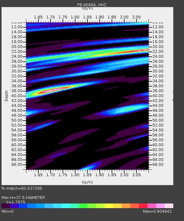
| Estimated Moho Depth: |
37.5 km |
| Estimated Crust Vp/Vs: |
1.71 |
| Assumed Crust Vp: |
6.264 km/s |
| Estimated Crust Vs: |
3.668 km/s |
| Estimated Crust Poisson's Ratio: |
0.24 |
|
| Radial Match: |
80.537285 % |
| Radial Bump: |
400 |
| Transverse Match: |
77.87212 % |
| Transverse Bump: |
400 |
| SOD ConfigId: |
3390531 |
| Insert Time: |
2019-04-10 16:42:54.538 +0000 |
| GWidth: |
2.5 |
| Max Bumps: |
400 |
| Tol: |
0.001 |
|

Signal To Noise
| Channel | StoN | STA | LTA |
| PB:B088A: :HHZ:20140316T00:00:04.668998Z | 5.2126446 | 1.0383962E-6 | 1.9920718E-7 |
| PB:B088A: :HHN:20140316T00:00:04.668998Z | 1.4741569 | 4.9190277E-7 | 3.3368414E-7 |
| PB:B088A: :HHE:20140316T00:00:04.668998Z | 2.235576 | 5.071845E-7 | 2.2686974E-7 |
| Arrivals |
| Ps | 4.5 SECOND |
| PpPs | 15 SECOND |
| PsPs/PpSs | 20 SECOND |


