You are here: Home > Network List > TA - USArray Transportable Network (new EarthScope stations) Stations List
> Station E62A Clayton Lake, ME, USA > Earthquake Result Viewer
E62A Clayton Lake, ME, USA - Earthquake Result Viewer
| Earthquake location: |
Near Coast Of Northern Peru |
| Earthquake latitude/longitude: |
-5.6/-81.0 |
| Earthquake time(UTC): |
2014/03/15 (074) 23:51:33 GMT |
| Earthquake Depth: |
29 km |
| Earthquake Magnitude: |
6.3 MWW, 6.2 MWB, 6.3 MWC |
| Earthquake Catalog/Contributor: |
NEIC PDE/NEIC COMCAT |
|
| Network: |
TA USArray Transportable Network (new EarthScope stations) |
| Station: |
E62A Clayton Lake, ME, USA |
| Lat/Lon: |
46.62 N/69.52 W |
| Elevation: |
356 m |
|
| Distance: |
53.0 deg |
| Az: |
9.857 deg |
| Baz: |
194.312 deg |
| Ray Param: |
0.06637276 |
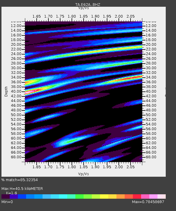
| Estimated Moho Depth: |
40.5 km |
| Estimated Crust Vp/Vs: |
1.60 |
| Assumed Crust Vp: |
6.419 km/s |
| Estimated Crust Vs: |
4.012 km/s |
| Estimated Crust Poisson's Ratio: |
0.18 |
|
| Radial Match: |
85.32354 % |
| Radial Bump: |
400 |
| Transverse Match: |
75.43229 % |
| Transverse Bump: |
400 |
| SOD ConfigId: |
3390531 |
| Insert Time: |
2019-04-10 16:43:22.881 +0000 |
| GWidth: |
2.5 |
| Max Bumps: |
400 |
| Tol: |
0.001 |
|
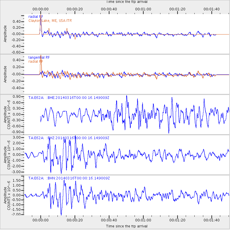
Signal To Noise
| Channel | StoN | STA | LTA |
| TA:E62A: :BHZ:20140316T00:00:16.149009Z | 2.7127917 | 8.217684E-7 | 3.0292352E-7 |
| TA:E62A: :BHN:20140316T00:00:16.149009Z | 1.9705629 | 2.8384866E-7 | 1.4404446E-7 |
| TA:E62A: :BHE:20140316T00:00:16.149009Z | 0.80214375 | 1.7047708E-7 | 2.1252684E-7 |
| Arrivals |
| Ps | 4.0 SECOND |
| PpPs | 15 SECOND |
| PsPs/PpSs | 19 SECOND |


