You are here: Home > Network List > TA - USArray Transportable Network (new EarthScope stations) Stations List
> Station K63A Dunstable, MA, USA > Earthquake Result Viewer
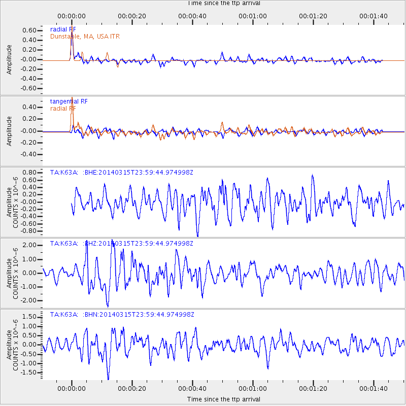
K63A Dunstable, MA, USA - Earthquake Result Viewer
*The percent match for this event was below the threshold and hence no stack was calculated.
| Earthquake location: |
Near Coast Of Northern Peru |
| Earthquake latitude/longitude: |
-5.6/-81.0 |
| Earthquake time(UTC): |
2014/03/15 (074) 23:51:33 GMT |
| Earthquake Depth: |
29 km |
| Earthquake Magnitude: |
6.3 MWW, 6.2 MWB, 6.3 MWC |
| Earthquake Catalog/Contributor: |
NEIC PDE/NEIC COMCAT |
|
| Network: |
TA USArray Transportable Network (new EarthScope stations) |
| Station: |
K63A Dunstable, MA, USA |
| Lat/Lon: |
42.69 N/71.53 W |
| Elevation: |
68 m |
|
| Distance: |
48.8 deg |
| Az: |
9.237 deg |
| Baz: |
192.515 deg |
| Ray Param: |
$rayparam |
*The percent match for this event was below the threshold and hence was not used in the summary stack. |
|
| Radial Match: |
74.29015 % |
| Radial Bump: |
400 |
| Transverse Match: |
60.429356 % |
| Transverse Bump: |
400 |
| SOD ConfigId: |
3390531 |
| Insert Time: |
2019-04-10 16:43:35.895 +0000 |
| GWidth: |
2.5 |
| Max Bumps: |
400 |
| Tol: |
0.001 |
|
Signal To Noise
| Channel | StoN | STA | LTA |
| TA:K63A: :BHZ:20140315T23:59:44.974998Z | 2.4067655 | 5.785085E-7 | 2.4036763E-7 |
| TA:K63A: :BHN:20140315T23:59:44.974998Z | 1.9320958 | 4.5320766E-7 | 2.3456789E-7 |
| TA:K63A: :BHE:20140315T23:59:44.974998Z | 1.3134876 | 2.869643E-7 | 2.1847507E-7 |
| Arrivals |
| Ps | |
| PpPs | |
| PsPs/PpSs | |


