You are here: Home > Network List > TA - USArray Transportable Network (new EarthScope stations) Stations List
> Station C33A Trail, MN, USA > Earthquake Result Viewer
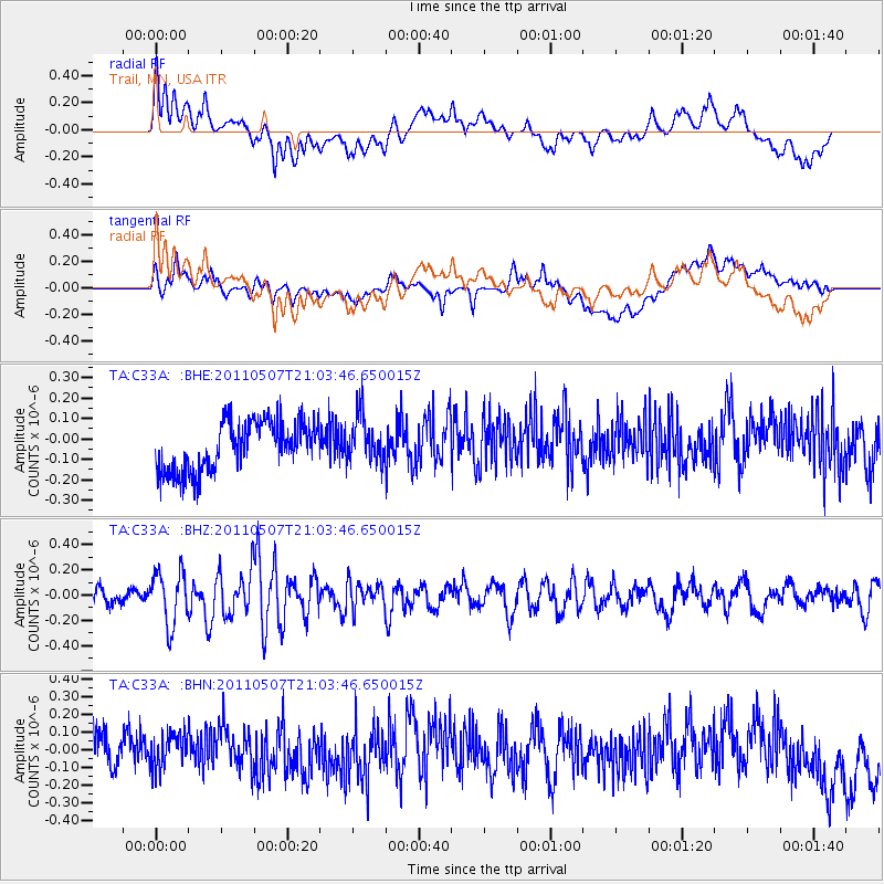
C33A Trail, MN, USA - Earthquake Result Viewer
*The percent match for this event was below the threshold and hence no stack was calculated.
| Earthquake location: |
Near East Coast Of Honshu, Japan |
| Earthquake latitude/longitude: |
40.2/142.2 |
| Earthquake time(UTC): |
2011/05/07 (127) 20:52:20 GMT |
| Earthquake Depth: |
35 km |
| Earthquake Magnitude: |
5.5 MB, 5.2 MS, 5.7 MW, 5.7 MW |
| Earthquake Catalog/Contributor: |
WHDF/NEIC |
|
| Network: |
TA USArray Transportable Network (new EarthScope stations) |
| Station: |
C33A Trail, MN, USA |
| Lat/Lon: |
47.76 N/95.77 W |
| Elevation: |
388 m |
|
| Distance: |
78.4 deg |
| Az: |
35.751 deg |
| Baz: |
318.482 deg |
| Ray Param: |
$rayparam |
*The percent match for this event was below the threshold and hence was not used in the summary stack. |
|
| Radial Match: |
54.33687 % |
| Radial Bump: |
400 |
| Transverse Match: |
62.80334 % |
| Transverse Bump: |
400 |
| SOD ConfigId: |
390285 |
| Insert Time: |
2011-10-18 05:49:00.037 +0000 |
| GWidth: |
2.5 |
| Max Bumps: |
400 |
| Tol: |
0.001 |
|
Signal To Noise
| Channel | StoN | STA | LTA |
| TA:C33A: :BHZ:20110507T21:03:46.650015Z | 3.5468931 | 2.0985144E-7 | 5.9164858E-8 |
| TA:C33A: :BHN:20110507T21:03:46.650015Z | 0.8210146 | 9.577607E-8 | 1.1665575E-7 |
| TA:C33A: :BHE:20110507T21:03:46.650015Z | 0.93599665 | 1.1318273E-7 | 1.2092215E-7 |
| Arrivals |
| Ps | |
| PpPs | |
| PsPs/PpSs | |


