You are here: Home > Network List > TA - USArray Transportable Network (new EarthScope stations) Stations List
> Station G34A Benson, MN, USA > Earthquake Result Viewer
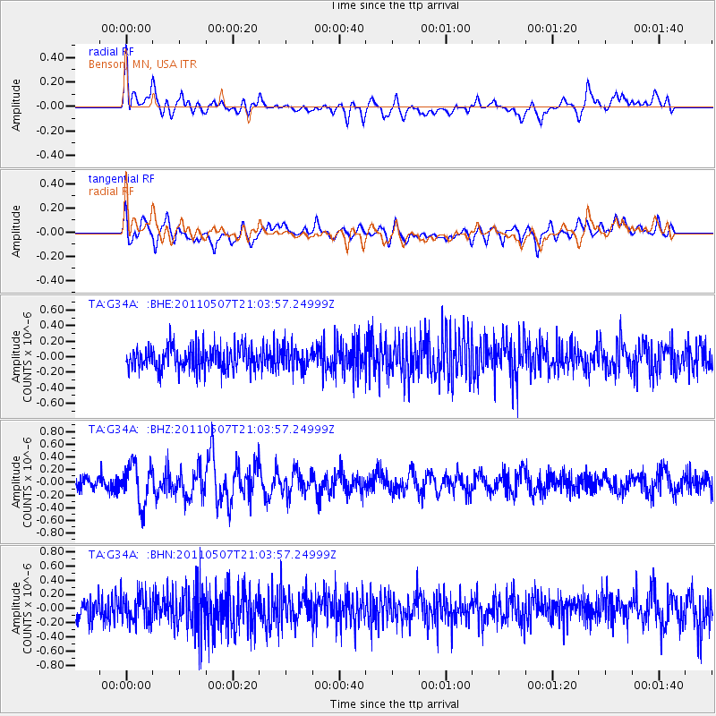
G34A Benson, MN, USA - Earthquake Result Viewer
*The percent match for this event was below the threshold and hence no stack was calculated.
| Earthquake location: |
Near East Coast Of Honshu, Japan |
| Earthquake latitude/longitude: |
40.2/142.2 |
| Earthquake time(UTC): |
2011/05/07 (127) 20:52:20 GMT |
| Earthquake Depth: |
35 km |
| Earthquake Magnitude: |
5.5 MB, 5.2 MS, 5.7 MW, 5.7 MW |
| Earthquake Catalog/Contributor: |
WHDF/NEIC |
|
| Network: |
TA USArray Transportable Network (new EarthScope stations) |
| Station: |
G34A Benson, MN, USA |
| Lat/Lon: |
45.24 N/95.64 W |
| Elevation: |
316 m |
|
| Distance: |
80.3 deg |
| Az: |
37.371 deg |
| Baz: |
318.878 deg |
| Ray Param: |
$rayparam |
*The percent match for this event was below the threshold and hence was not used in the summary stack. |
|
| Radial Match: |
58.08221 % |
| Radial Bump: |
400 |
| Transverse Match: |
66.78698 % |
| Transverse Bump: |
400 |
| SOD ConfigId: |
390285 |
| Insert Time: |
2011-10-18 05:49:57.826 +0000 |
| GWidth: |
2.5 |
| Max Bumps: |
400 |
| Tol: |
0.001 |
|
Signal To Noise
| Channel | StoN | STA | LTA |
| TA:G34A: :BHZ:20110507T21:03:57.24999Z | 2.6914968 | 3.1389223E-7 | 1.1662367E-7 |
| TA:G34A: :BHN:20110507T21:03:57.24999Z | 1.3056153 | 2.0581908E-7 | 1.5764144E-7 |
| TA:G34A: :BHE:20110507T21:03:57.24999Z | 0.9117429 | 1.3615882E-7 | 1.4933904E-7 |
| Arrivals |
| Ps | |
| PpPs | |
| PsPs/PpSs | |


