You are here: Home > Network List > TA - USArray Transportable Network (new EarthScope stations) Stations List
> Station U40A Yellville, AR, USA > Earthquake Result Viewer
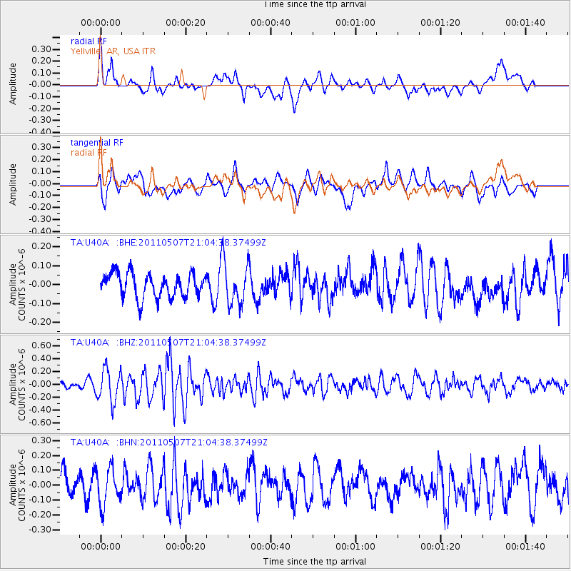
U40A Yellville, AR, USA - Earthquake Result Viewer
*The percent match for this event was below the threshold and hence no stack was calculated.
| Earthquake location: |
Near East Coast Of Honshu, Japan |
| Earthquake latitude/longitude: |
40.2/142.2 |
| Earthquake time(UTC): |
2011/05/07 (127) 20:52:20 GMT |
| Earthquake Depth: |
35 km |
| Earthquake Magnitude: |
5.5 MB, 5.2 MS, 5.7 MW, 5.7 MW |
| Earthquake Catalog/Contributor: |
WHDF/NEIC |
|
| Network: |
TA USArray Transportable Network (new EarthScope stations) |
| Station: |
U40A Yellville, AR, USA |
| Lat/Lon: |
36.36 N/92.85 W |
| Elevation: |
374 m |
|
| Distance: |
88.5 deg |
| Az: |
41.472 deg |
| Baz: |
321.097 deg |
| Ray Param: |
$rayparam |
*The percent match for this event was below the threshold and hence was not used in the summary stack. |
|
| Radial Match: |
58.034233 % |
| Radial Bump: |
400 |
| Transverse Match: |
59.807697 % |
| Transverse Bump: |
400 |
| SOD ConfigId: |
390285 |
| Insert Time: |
2011-10-18 05:54:42.855 +0000 |
| GWidth: |
2.5 |
| Max Bumps: |
400 |
| Tol: |
0.001 |
|
Signal To Noise
| Channel | StoN | STA | LTA |
| TA:U40A: :BHZ:20110507T21:04:38.37499Z | 4.3189616 | 2.5633958E-7 | 5.9352132E-8 |
| TA:U40A: :BHN:20110507T21:04:38.37499Z | 1.9770542 | 1.2346081E-7 | 6.244685E-8 |
| TA:U40A: :BHE:20110507T21:04:38.37499Z | 1.5728143 | 1.0012822E-7 | 6.3661815E-8 |
| Arrivals |
| Ps | |
| PpPs | |
| PsPs/PpSs | |


