You are here: Home > Network List > Z910 - Southeastern Suture of the Appalachian Margin Experiment Stations List
> Station D07 Ogden Property, Tignall, GA > Earthquake Result Viewer
D07 Ogden Property, Tignall, GA - Earthquake Result Viewer
| Earthquake location: |
Near Coast Of Northern Peru |
| Earthquake latitude/longitude: |
-5.6/-81.0 |
| Earthquake time(UTC): |
2014/03/15 (074) 23:51:33 GMT |
| Earthquake Depth: |
29 km |
| Earthquake Magnitude: |
6.3 MWW, 6.2 MWB, 6.3 MWC |
| Earthquake Catalog/Contributor: |
NEIC PDE/NEIC COMCAT |
|
| Network: |
Z9 Southeastern Suture of the Appalachian Margin Experiment |
| Station: |
D07 Ogden Property, Tignall, GA |
| Lat/Lon: |
33.94 N/82.69 W |
| Elevation: |
140 m |
|
| Distance: |
39.3 deg |
| Az: |
357.731 deg |
| Baz: |
177.283 deg |
| Ray Param: |
0.07499136 |
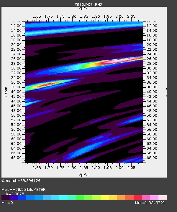
| Estimated Moho Depth: |
26.25 km |
| Estimated Crust Vp/Vs: |
2.01 |
| Assumed Crust Vp: |
6.565 km/s |
| Estimated Crust Vs: |
3.27 km/s |
| Estimated Crust Poisson's Ratio: |
0.33 |
|
| Radial Match: |
89.396126 % |
| Radial Bump: |
217 |
| Transverse Match: |
59.75769 % |
| Transverse Bump: |
400 |
| SOD ConfigId: |
3390531 |
| Insert Time: |
2019-04-10 16:46:34.138 +0000 |
| GWidth: |
2.5 |
| Max Bumps: |
400 |
| Tol: |
0.001 |
|

Signal To Noise
| Channel | StoN | STA | LTA |
| Z9:D07: :BHZ:20140315T23:58:29.339988Z | 5.6942415 | 8.484769E-7 | 1.4900613E-7 |
| Z9:D07: :BHN:20140315T23:58:29.339988Z | 4.4189024 | 5.4769214E-7 | 1.2394302E-7 |
| Z9:D07: :BHE:20140315T23:58:29.339988Z | 0.9337526 | 1.1480562E-7 | 1.229508E-7 |
| Arrivals |
| Ps | 4.3 SECOND |
| PpPs | 11 SECOND |
| PsPs/PpSs | 16 SECOND |


