You are here: Home > Network List > Z910 - Southeastern Suture of the Appalachian Margin Experiment Stations List
> Station D10 Paul Property, Elberton, GA > Earthquake Result Viewer
D10 Paul Property, Elberton, GA - Earthquake Result Viewer
| Earthquake location: |
Near Coast Of Northern Peru |
| Earthquake latitude/longitude: |
-5.6/-81.0 |
| Earthquake time(UTC): |
2014/03/15 (074) 23:51:33 GMT |
| Earthquake Depth: |
29 km |
| Earthquake Magnitude: |
6.3 MWW, 6.2 MWB, 6.3 MWC |
| Earthquake Catalog/Contributor: |
NEIC PDE/NEIC COMCAT |
|
| Network: |
Z9 Southeastern Suture of the Appalachian Margin Experiment |
| Station: |
D10 Paul Property, Elberton, GA |
| Lat/Lon: |
34.09 N/82.90 W |
| Elevation: |
186 m |
|
| Distance: |
39.5 deg |
| Az: |
357.46 deg |
| Baz: |
176.953 deg |
| Ray Param: |
0.074897535 |
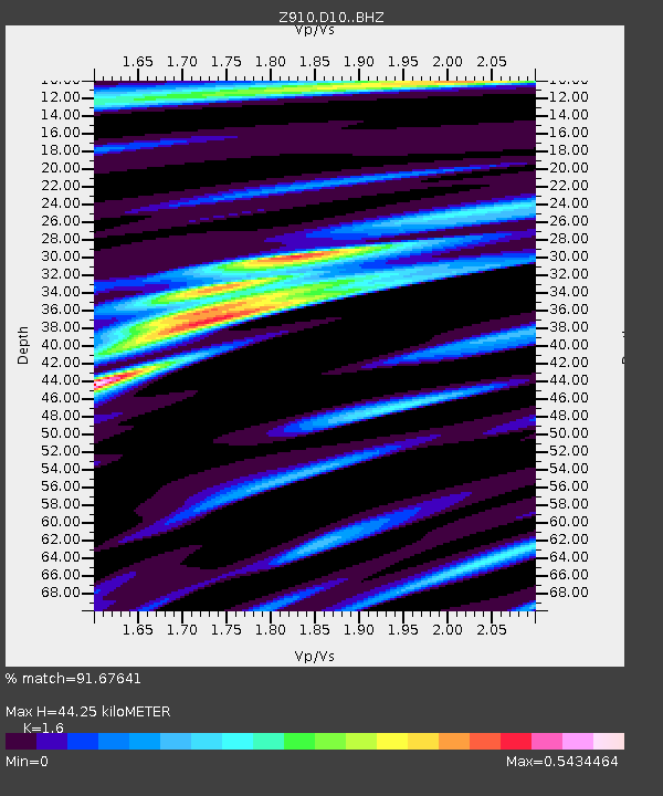
| Estimated Moho Depth: |
44.25 km |
| Estimated Crust Vp/Vs: |
1.60 |
| Assumed Crust Vp: |
6.35 km/s |
| Estimated Crust Vs: |
3.969 km/s |
| Estimated Crust Poisson's Ratio: |
0.18 |
|
| Radial Match: |
91.67641 % |
| Radial Bump: |
240 |
| Transverse Match: |
58.803337 % |
| Transverse Bump: |
400 |
| SOD ConfigId: |
3390531 |
| Insert Time: |
2019-04-10 16:46:38.062 +0000 |
| GWidth: |
2.5 |
| Max Bumps: |
400 |
| Tol: |
0.001 |
|

Signal To Noise
| Channel | StoN | STA | LTA |
| Z9:D10: :BHZ:20140315T23:58:30.700004Z | 5.6031494 | 8.888883E-7 | 1.5864084E-7 |
| Z9:D10: :BHN:20140315T23:58:30.700004Z | 6.747382 | 6.1396196E-7 | 9.0992614E-8 |
| Z9:D10: :BHE:20140315T23:58:30.700004Z | 0.87711334 | 1.6575976E-7 | 1.8898328E-7 |
| Arrivals |
| Ps | 4.5 SECOND |
| PpPs | 17 SECOND |
| PsPs/PpSs | 21 SECOND |


