You are here: Home > Network List > Z910 - Southeastern Suture of the Appalachian Margin Experiment Stations List
> Station D15 Vandiver Farm, Carnesville, GA > Earthquake Result Viewer
D15 Vandiver Farm, Carnesville, GA - Earthquake Result Viewer
| Earthquake location: |
Near Coast Of Northern Peru |
| Earthquake latitude/longitude: |
-5.6/-81.0 |
| Earthquake time(UTC): |
2014/03/15 (074) 23:51:33 GMT |
| Earthquake Depth: |
29 km |
| Earthquake Magnitude: |
6.3 MWW, 6.2 MWB, 6.3 MWC |
| Earthquake Catalog/Contributor: |
NEIC PDE/NEIC COMCAT |
|
| Network: |
Z9 Southeastern Suture of the Appalachian Margin Experiment |
| Station: |
D15 Vandiver Farm, Carnesville, GA |
| Lat/Lon: |
34.45 N/83.28 W |
| Elevation: |
254 m |
|
| Distance: |
39.9 deg |
| Az: |
357.005 deg |
| Baz: |
176.391 deg |
| Ray Param: |
0.07467348 |
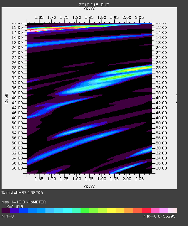
| Estimated Moho Depth: |
13.0 km |
| Estimated Crust Vp/Vs: |
1.62 |
| Assumed Crust Vp: |
6.35 km/s |
| Estimated Crust Vs: |
3.932 km/s |
| Estimated Crust Poisson's Ratio: |
0.19 |
|
| Radial Match: |
87.168205 % |
| Radial Bump: |
284 |
| Transverse Match: |
55.454563 % |
| Transverse Bump: |
400 |
| SOD ConfigId: |
3390531 |
| Insert Time: |
2019-04-10 16:46:40.539 +0000 |
| GWidth: |
2.5 |
| Max Bumps: |
400 |
| Tol: |
0.001 |
|

Signal To Noise
| Channel | StoN | STA | LTA |
| Z9:D15: :BHZ:20140315T23:58:33.80001Z | 5.4138713 | 6.912464E-7 | 1.2768061E-7 |
| Z9:D15: :BHN:20140315T23:58:33.80001Z | 4.148561 | 5.199426E-7 | 1.2533083E-7 |
| Z9:D15: :BHE:20140315T23:58:33.80001Z | 0.6424055 | 7.99068E-8 | 1.2438684E-7 |
| Arrivals |
| Ps | 1.4 SECOND |
| PpPs | 5.0 SECOND |
| PsPs/PpSs | 6.3 SECOND |


