You are here: Home > Network List > KN - Kyrgyz Seismic Telemetry Network Stations List
> Station TKM2 KN.TKM2 > Earthquake Result Viewer
TKM2 KN.TKM2 - Earthquake Result Viewer
*The percent match for this event was below the threshold and hence no stack was calculated.
| Earthquake location: |
Mindanao, Philippines |
| Earthquake latitude/longitude: |
5.3/126.4 |
| Earthquake time(UTC): |
2011/05/09 (129) 19:13:25 GMT |
| Earthquake Depth: |
29 km |
| Earthquake Magnitude: |
5.5 MB, 5.5 MS, 5.7 MW |
| Earthquake Catalog/Contributor: |
WHDF/NEIC |
|
| Network: |
KN Kyrgyz Seismic Telemetry Network |
| Station: |
TKM2 KN.TKM2 |
| Lat/Lon: |
42.92 N/75.60 E |
| Elevation: |
2020 m |
|
| Distance: |
58.3 deg |
| Az: |
318.014 deg |
| Baz: |
114.938 deg |
| Ray Param: |
$rayparam |
*The percent match for this event was below the threshold and hence was not used in the summary stack. |
|
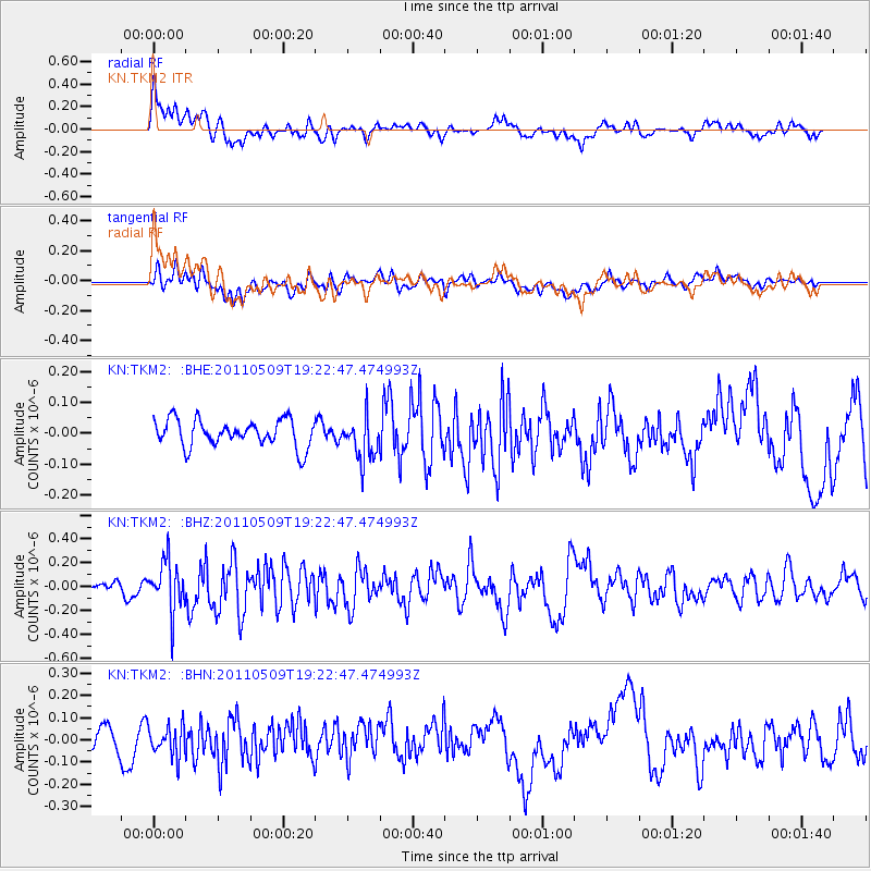
| Radial Match: |
70.36156 % |
| Radial Bump: |
400 |
| Transverse Match: |
55.35565 % |
| Transverse Bump: |
400 |
| SOD ConfigId: |
390285 |
| Insert Time: |
2011-10-18 06:11:35.703 +0000 |
| GWidth: |
2.5 |
| Max Bumps: |
400 |
| Tol: |
0.001 |
|
Signal To Noise
| Channel | StoN | STA | LTA |
| KN:TKM2: :BHZ:20110509T19:22:47.474993Z | 2.8798683 | 2.1188751E-7 | 7.3575414E-8 |
| KN:TKM2: :BHN:20110509T19:22:47.474993Z | 1.4597431 | 6.954713E-8 | 4.7643397E-8 |
| KN:TKM2: :BHE:20110509T19:22:47.474993Z | 1.6330141 | 7.0816164E-8 | 4.336531E-8 |
| Arrivals |
| Ps | |
| PpPs | |
| PsPs/PpSs | |


