You are here: Home > Network List > Z910 - Southeastern Suture of the Appalachian Margin Experiment Stations List
> Station W35 Gibson Property, Young Harris, GA > Earthquake Result Viewer
W35 Gibson Property, Young Harris, GA - Earthquake Result Viewer
| Earthquake location: |
Near Coast Of Northern Peru |
| Earthquake latitude/longitude: |
-5.6/-81.0 |
| Earthquake time(UTC): |
2014/03/15 (074) 23:51:33 GMT |
| Earthquake Depth: |
29 km |
| Earthquake Magnitude: |
6.3 MWW, 6.2 MWB, 6.3 MWC |
| Earthquake Catalog/Contributor: |
NEIC PDE/NEIC COMCAT |
|
| Network: |
Z9 Southeastern Suture of the Appalachian Margin Experiment |
| Station: |
W35 Gibson Property, Young Harris, GA |
| Lat/Lon: |
34.98 N/83.94 W |
| Elevation: |
539 m |
|
| Distance: |
40.4 deg |
| Az: |
356.217 deg |
| Baz: |
175.413 deg |
| Ray Param: |
0.074351236 |
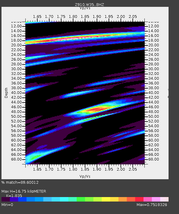
| Estimated Moho Depth: |
16.75 km |
| Estimated Crust Vp/Vs: |
1.84 |
| Assumed Crust Vp: |
6.35 km/s |
| Estimated Crust Vs: |
3.46 km/s |
| Estimated Crust Poisson's Ratio: |
0.29 |
|
| Radial Match: |
89.60012 % |
| Radial Bump: |
295 |
| Transverse Match: |
66.403336 % |
| Transverse Bump: |
400 |
| SOD ConfigId: |
3390531 |
| Insert Time: |
2019-04-10 16:47:17.618 +0000 |
| GWidth: |
2.5 |
| Max Bumps: |
400 |
| Tol: |
0.001 |
|

Signal To Noise
| Channel | StoN | STA | LTA |
| Z9:W35: :BHZ:20140315T23:58:38.460013Z | 5.288084 | 7.6711467E-7 | 1.4506476E-7 |
| Z9:W35: :BHN:20140315T23:58:38.460013Z | 6.4866657 | 6.718719E-7 | 1.03577385E-7 |
| Z9:W35: :BHE:20140315T23:58:38.460013Z | 1.4702364 | 1.629909E-7 | 1.10860334E-7 |
| Arrivals |
| Ps | 2.4 SECOND |
| PpPs | 7.0 SECOND |
| PsPs/PpSs | 9.4 SECOND |


