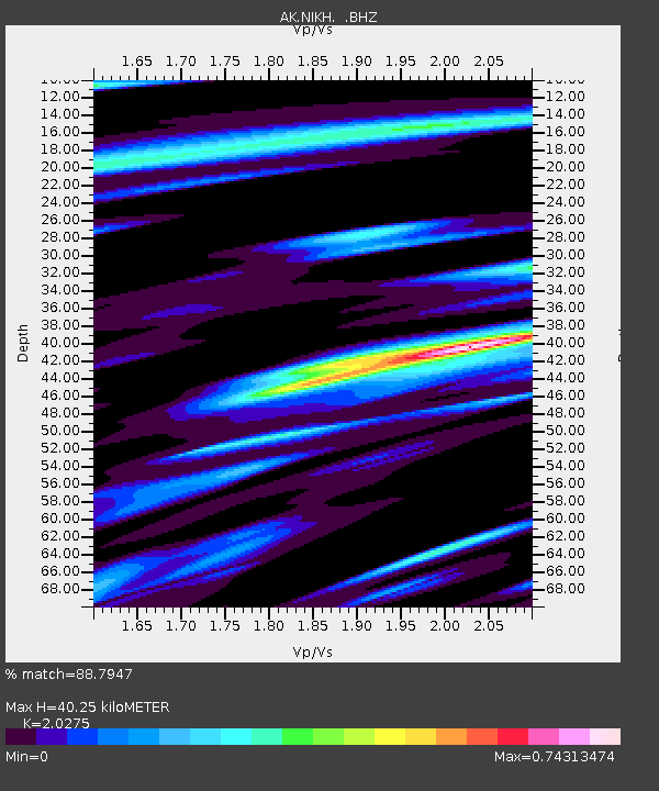
NIKH Nikolski High Hill - Earthquake Result Viewer

Earthquake location: Loyalty Islands
Earthquake latitude/longitude: -20.2/168.2
Earthquake time(UTC): 2011/05/10 (130) 08:55:08 GMT
Earthquake Depth: 11 km
Earthquake Magnitude: 6.4 MB, 6.8 MS, 6.9 MW, 6.8 MW
Earthquake Catalog/Contributor: WHDF/NEIC
Network: AK Alaska Regional Network
Station: NIKH Nikolski High Hill
Lat/Lon: 52.97 N/168.85 W
Elevation: 199 m
Distance: 75.6 deg
Az: 14.075 deg
Baz: 202.185 deg
Ray Param: 0.05157342
Estimated Moho Depth: 40.25 km
Estimated Crust Vp/Vs: 2.03
Assumed Crust Vp: 5.88 km/s
Estimated Crust Vs: 2.9 km/s
Estimated Crust Poisson's Ratio: 0.34
Radial Match: 88.7947 %
Radial Bump: 400
Transverse Match: 68.84597 %
Transverse Bump: 400
SOD ConfigId: 390285
Insert Time: 2011-10-18 06:36:16.574 +0000
GWidth: 2.5
Max Bumps: 400
Tol: 0.001

Signal To Noise

ChannelStoNSTALTA
AK:NIKH: :BHZ:20110510T09:06:22.227974Z9.5326958.854229E-69.2882755E-7
AK:NIKH: :BHN:20110510T09:06:22.227974Z3.27500443.027638E-69.244684E-7
AK:NIKH: :BHE:20110510T09:06:22.227974Z1.45893921.9721022E-61.3517371E-6
Arrivals
Ps7.2 SECOND
PpPs20 SECOND
PsPs/PpSs27 SECOND