You are here: Home > Network List > TJ - Tajikistan National Seismic Network Stations List
> Station SHAA Shaartuz, Tajikistan > Earthquake Result Viewer
SHAA Shaartuz, Tajikistan - Earthquake Result Viewer
| Earthquake location: |
Banda Sea |
| Earthquake latitude/longitude: |
-7.5/126.0 |
| Earthquake time(UTC): |
2014/03/16 (075) 01:00:15 GMT |
| Earthquake Depth: |
433 km |
| Earthquake Magnitude: |
5.0 mb |
| Earthquake Catalog/Contributor: |
ISC/ISC |
|
| Network: |
TJ Tajikistan National Seismic Network |
| Station: |
SHAA Shaartuz, Tajikistan |
| Lat/Lon: |
37.56 N/68.12 E |
| Elevation: |
868 m |
|
| Distance: |
70.1 deg |
| Az: |
314.295 deg |
| Baz: |
116.728 deg |
| Ray Param: |
0.053842355 |
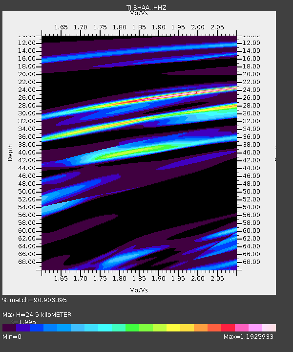
| Estimated Moho Depth: |
24.5 km |
| Estimated Crust Vp/Vs: |
2.00 |
| Assumed Crust Vp: |
6.213 km/s |
| Estimated Crust Vs: |
3.114 km/s |
| Estimated Crust Poisson's Ratio: |
0.33 |
|
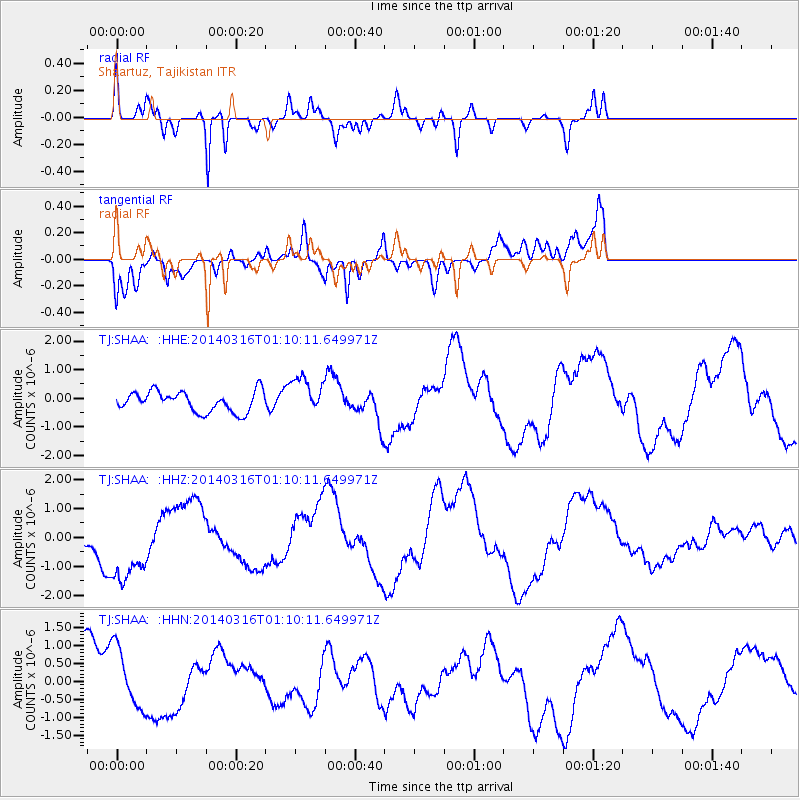
| Radial Match: |
90.906395 % |
| Radial Bump: |
292 |
| Transverse Match: |
73.49019 % |
| Transverse Bump: |
400 |
| SOD ConfigId: |
3390531 |
| Insert Time: |
2019-04-10 16:49:17.610 +0000 |
| GWidth: |
2.5 |
| Max Bumps: |
400 |
| Tol: |
0.001 |
|
Signal To Noise
| Channel | StoN | STA | LTA |
| TJ:SHAA: :HHZ:20140316T01:10:11.649971Z | 1.7599919 | 1.3620407E-6 | 7.7389035E-7 |
| TJ:SHAA: :HHN:20140316T01:10:11.649971Z | 0.8298605 | 8.3355144E-7 | 1.0044477E-6 |
| TJ:SHAA: :HHE:20140316T01:10:11.649971Z | 1.8022234 | 6.412222E-7 | 3.5579504E-7 |
| Arrivals |
| Ps | 4.0 SECOND |
| PpPs | 11 SECOND |
| PsPs/PpSs | 16 SECOND |


