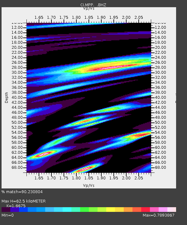
MPP McPhearson Peak - Earthquake Result Viewer
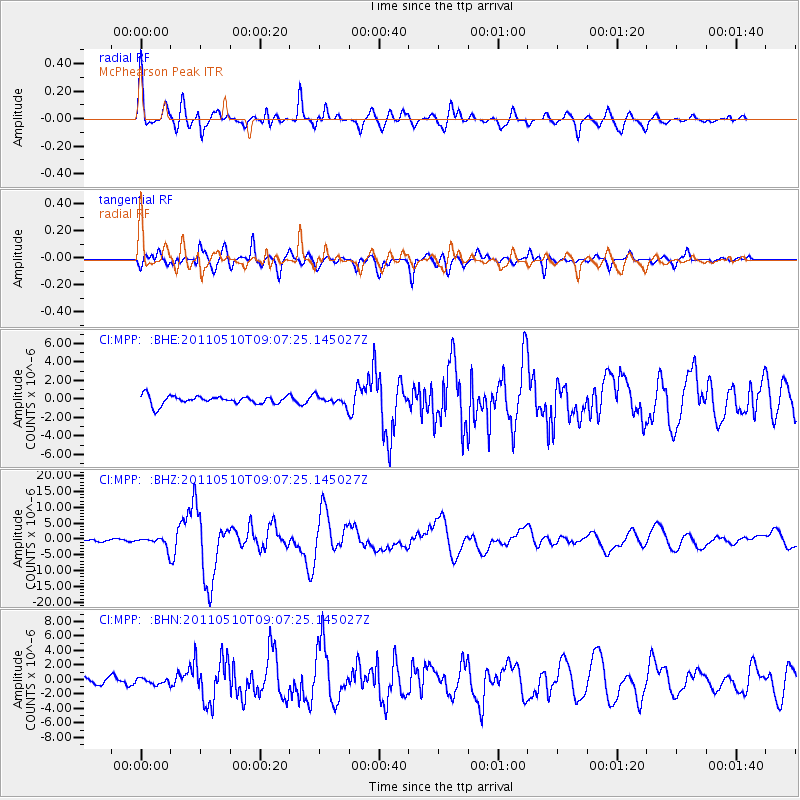
Earthquake location: Loyalty Islands
Earthquake latitude/longitude: -20.2/168.2
Earthquake time(UTC): 2011/05/10 (130) 08:55:08 GMT
Earthquake Depth: 11 km
Earthquake Magnitude: 6.4 MB, 6.8 MS, 6.9 MW, 6.8 MW
Earthquake Catalog/Contributor: WHDF/NEIC
Network: CI Caltech Regional Seismic Network
Station: MPP McPhearson Peak
Lat/Lon: 34.89 N/119.81 W
Elevation: 1739 m
Distance: 87.5 deg
Az: 51.479 deg
Baz: 243.336 deg
Ray Param: 0.043262634
Estimated Moho Depth: 62.5 km
Estimated Crust Vp/Vs: 1.67
Assumed Crust Vp: 6.1 km/s
Estimated Crust Vs: 3.658 km/s
Estimated Crust Poisson's Ratio: 0.22
Radial Match: 90.230804 %
Radial Bump: 400
Transverse Match: 88.9043 %
Transverse Bump: 400
SOD ConfigId: 390285
Insert Time: 2011-10-18 06:45:57.875 +0000
GWidth: 2.5
Max Bumps: 400
Tol: 0.001

Signal To Noise

ChannelStoNSTALTA
CI:MPP: :BHZ:20110510T09:07:25.145027Z4.61186271.7550124E-63.8054304E-7
CI:MPP: :BHN:20110510T09:07:25.145027Z0.92020984.099036E-74.454458E-7
CI:MPP: :BHE:20110510T09:07:25.145027Z1.04169134.845522E-74.6515905E-7
Arrivals
Ps7.0 SECOND
PpPs27 SECOND
PsPs/PpSs34 SECOND