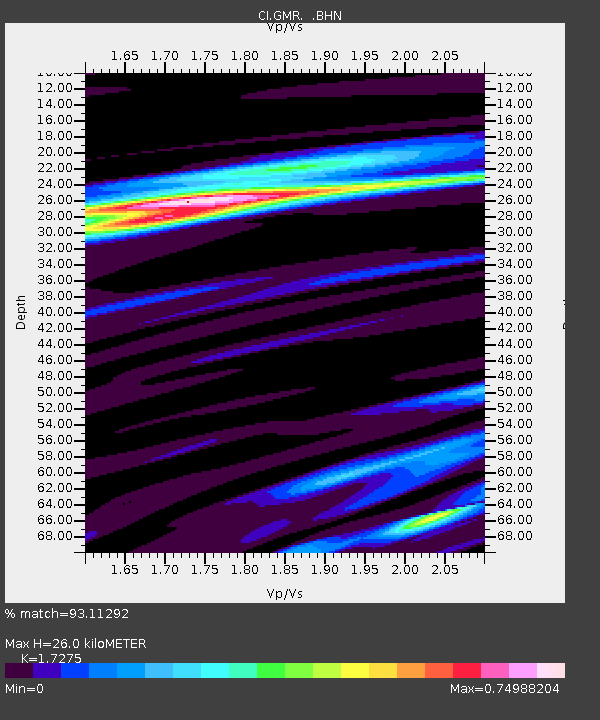
GMR Granite Mountains Research Center - Earthquake Result Viewer
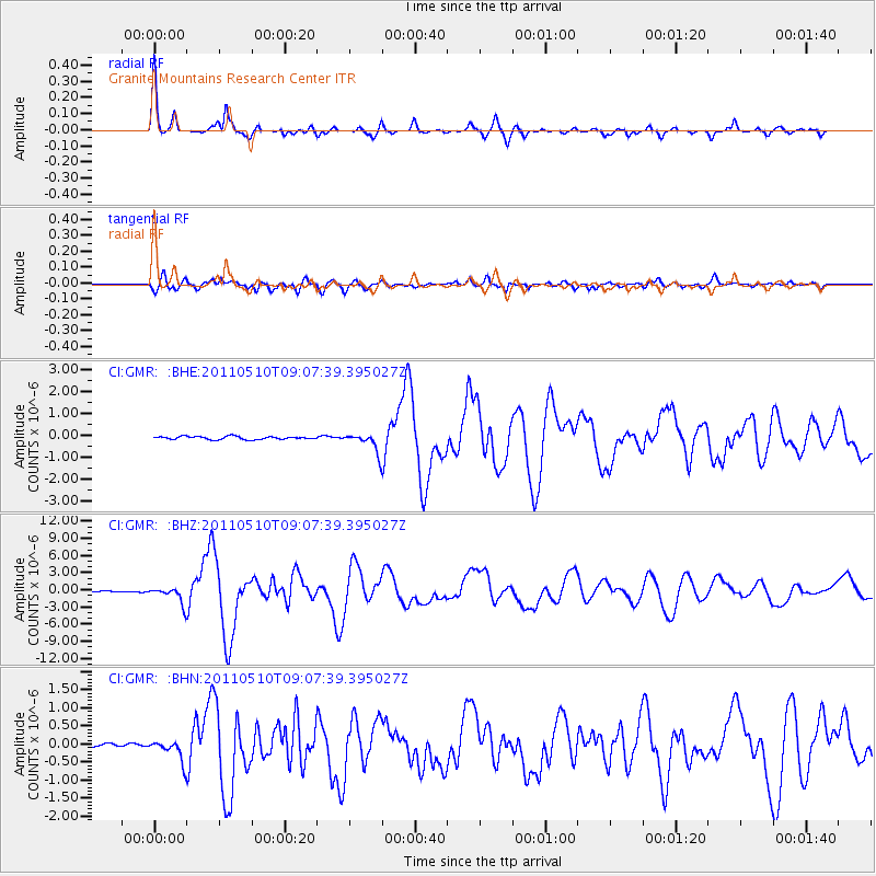
Earthquake location: Loyalty Islands
Earthquake latitude/longitude: -20.2/168.2
Earthquake time(UTC): 2011/05/10 (130) 08:55:08 GMT
Earthquake Depth: 11 km
Earthquake Magnitude: 6.4 MB, 6.8 MS, 6.9 MW, 6.8 MW
Earthquake Catalog/Contributor: WHDF/NEIC
Network: CI Caltech Regional Seismic Network
Station: GMR Granite Mountains Research Center
Lat/Lon: 34.78 N/115.66 W
Elevation: 1326 m
Distance: 90.6 deg
Az: 53.042 deg
Baz: 245.725 deg
Ray Param: 0.041664127
Estimated Moho Depth: 26.0 km
Estimated Crust Vp/Vs: 1.73
Assumed Crust Vp: 6.276 km/s
Estimated Crust Vs: 3.633 km/s
Estimated Crust Poisson's Ratio: 0.25
Radial Match: 93.11292 %
Radial Bump: 358
Transverse Match: 87.435524 %
Transverse Bump: 400
SOD ConfigId: 390285
Insert Time: 2011-10-18 06:47:21.386 +0000
GWidth: 2.5
Max Bumps: 400
Tol: 0.001

Signal To Noise

ChannelStoNSTALTA
CI:GMR: :BHZ:20110510T09:07:39.395027Z21.7009071.4295574E-66.587547E-8
CI:GMR: :BHN:20110510T09:07:39.395027Z3.48985122.8704275E-78.225071E-8
CI:GMR: :BHE:20110510T09:07:39.395027Z6.67379574.5078013E-76.754479E-8
Arrivals
Ps3.1 SECOND
PpPs11 SECOND
PsPs/PpSs14 SECOND