You are here: Home > Network List > GE - GEOFON Stations List
> Station SNAA GEOFON/AWI Station Sanae, Antarctica > Earthquake Result Viewer
SNAA GEOFON/AWI Station Sanae, Antarctica - Earthquake Result Viewer
| Earthquake location: |
Loyalty Islands |
| Earthquake latitude/longitude: |
-20.2/168.2 |
| Earthquake time(UTC): |
2011/05/10 (130) 08:55:08 GMT |
| Earthquake Depth: |
11 km |
| Earthquake Magnitude: |
6.4 MB, 6.8 MS, 6.9 MW, 6.8 MW |
| Earthquake Catalog/Contributor: |
WHDF/NEIC |
|
| Network: |
GE GEOFON |
| Station: |
SNAA GEOFON/AWI Station Sanae, Antarctica |
| Lat/Lon: |
71.67 S/2.84 W |
| Elevation: |
846 m |
|
| Distance: |
88.1 deg |
| Az: |
182.818 deg |
| Baz: |
171.609 deg |
| Ray Param: |
0.04282245 |
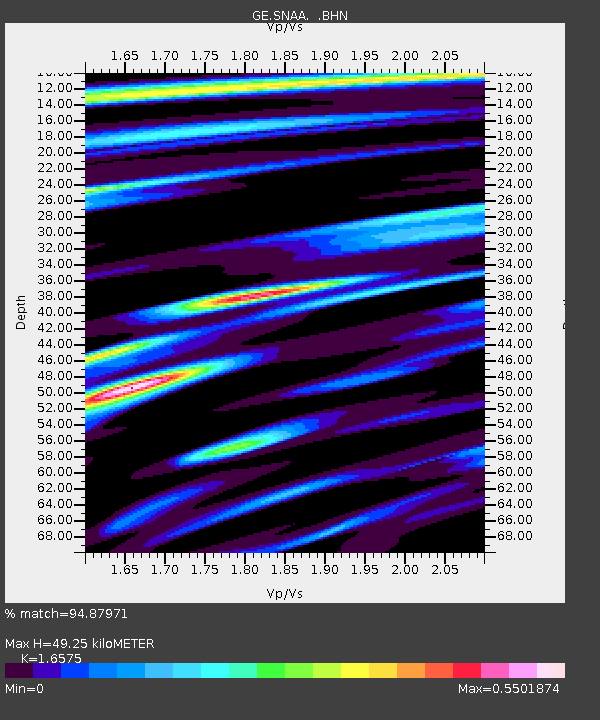
| Estimated Moho Depth: |
49.25 km |
| Estimated Crust Vp/Vs: |
1.66 |
| Assumed Crust Vp: |
6.43 km/s |
| Estimated Crust Vs: |
3.879 km/s |
| Estimated Crust Poisson's Ratio: |
0.21 |
|
| Radial Match: |
94.87971 % |
| Radial Bump: |
400 |
| Transverse Match: |
77.70083 % |
| Transverse Bump: |
400 |
| SOD ConfigId: |
390285 |
| Insert Time: |
2011-10-18 06:47:49.245 +0000 |
| GWidth: |
2.5 |
| Max Bumps: |
400 |
| Tol: |
0.001 |
|
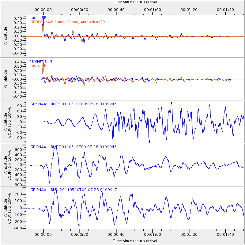
Signal To Noise
| Channel | StoN | STA | LTA |
| GE:SNAA: :BHZ:20110510T09:07:28.010994Z | 20.195757 | 2.5878663E-4 | 1.2813911E-5 |
| GE:SNAA: :BHN:20110510T09:07:28.010994Z | 9.067067 | 8.7680135E-5 | 9.670176E-6 |
| GE:SNAA: :BHE:20110510T09:07:28.010994Z | 2.6967666 | 3.5732217E-5 | 1.3250022E-5 |
| Arrivals |
| Ps | 5.2 SECOND |
| PpPs | 20 SECOND |
| PsPs/PpSs | 25 SECOND |


