You are here: Home > Network List > IW - Intermountain West Stations List
> Station IMW Indian Meadow, Wyoming, USA > Earthquake Result Viewer
IMW Indian Meadow, Wyoming, USA - Earthquake Result Viewer
| Earthquake location: |
Loyalty Islands |
| Earthquake latitude/longitude: |
-20.2/168.2 |
| Earthquake time(UTC): |
2011/05/10 (130) 08:55:08 GMT |
| Earthquake Depth: |
11 km |
| Earthquake Magnitude: |
6.4 MB, 6.8 MS, 6.9 MW, 6.8 MW |
| Earthquake Catalog/Contributor: |
WHDF/NEIC |
|
| Network: |
IW Intermountain West |
| Station: |
IMW Indian Meadow, Wyoming, USA |
| Lat/Lon: |
43.90 N/110.94 W |
| Elevation: |
2646 m |
|
| Distance: |
97.4 deg |
| Az: |
46.034 deg |
| Baz: |
249.207 deg |
| Ray Param: |
0.040211927 |
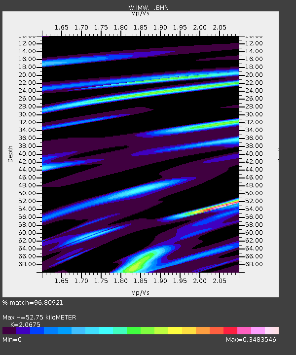
| Estimated Moho Depth: |
52.75 km |
| Estimated Crust Vp/Vs: |
2.07 |
| Assumed Crust Vp: |
6.207 km/s |
| Estimated Crust Vs: |
3.002 km/s |
| Estimated Crust Poisson's Ratio: |
0.35 |
|
| Radial Match: |
96.80921 % |
| Radial Bump: |
323 |
| Transverse Match: |
87.25841 % |
| Transverse Bump: |
400 |
| SOD ConfigId: |
390285 |
| Insert Time: |
2011-10-18 06:52:58.012 +0000 |
| GWidth: |
2.5 |
| Max Bumps: |
400 |
| Tol: |
0.001 |
|

Signal To Noise
| Channel | StoN | STA | LTA |
| IW:IMW: :BHZ:20110510T09:08:10.750007Z | 5.5932827 | 3.9016962E-7 | 6.975682E-8 |
| IW:IMW: :BHN:20110510T09:08:10.750007Z | 1.5408306 | 5.7799408E-8 | 3.751185E-8 |
| IW:IMW: :BHE:20110510T09:08:10.750007Z | 3.9907238 | 1.4698594E-7 | 3.68319E-8 |
| Arrivals |
| Ps | 9.2 SECOND |
| PpPs | 26 SECOND |
| PsPs/PpSs | 35 SECOND |


