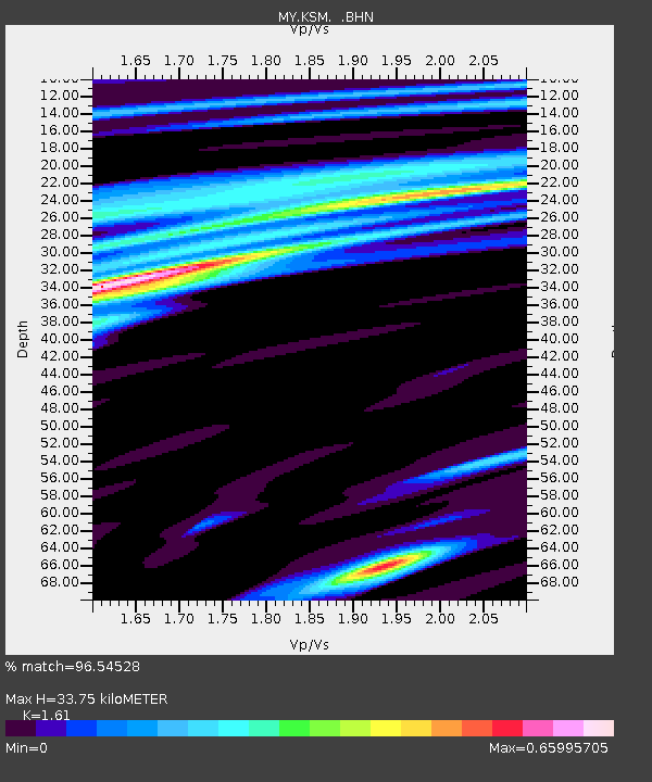
KSM Kuching - Earthquake Result Viewer

Earthquake location: Loyalty Islands
Earthquake latitude/longitude: -20.2/168.2
Earthquake time(UTC): 2011/05/10 (130) 08:55:08 GMT
Earthquake Depth: 11 km
Earthquake Magnitude: 6.4 MB, 6.8 MS, 6.9 MW, 6.8 MW
Earthquake Catalog/Contributor: WHDF/NEIC
Network: MY Malaysian National Seismic Network
Station: KSM Kuching
Lat/Lon: 1.47 N/110.31 E
Elevation: 66 m
Distance: 60.7 deg
Az: 283.709 deg
Baz: 114.143 deg
Ray Param: 0.061374143
Estimated Moho Depth: 33.75 km
Estimated Crust Vp/Vs: 1.61
Assumed Crust Vp: 6.468 km/s
Estimated Crust Vs: 4.017 km/s
Estimated Crust Poisson's Ratio: 0.19
Radial Match: 96.54528 %
Radial Bump: 318
Transverse Match: 91.94108 %
Transverse Bump: 400
SOD ConfigId: 390285
Insert Time: 2011-10-18 06:53:51.753 +0000
GWidth: 2.5
Max Bumps: 400
Tol: 0.001

Signal To Noise

ChannelStoNSTALTA
MY:KSM: :BHZ:20110510T09:04:48.91999Z22.4078831.8005326E-68.035264E-8
MY:KSM: :BHN:20110510T09:04:48.91999Z4.88062524.4947055E-79.209282E-8
MY:KSM: :BHE:20110510T09:04:48.91999Z6.69695665.6880015E-78.493412E-8
Arrivals
Ps3.4 SECOND
PpPs13 SECOND
PsPs/PpSs16 SECOND