You are here: Home > Network List > 7A - Mid-Atlantic Geophysical Integrative Collaboration Stations List
> Station LADY Linville, Virginia USA > Earthquake Result Viewer
LADY Linville, Virginia USA - Earthquake Result Viewer
| Earthquake location: |
Near Coast Of Northern Chile |
| Earthquake latitude/longitude: |
-19.9/-70.6 |
| Earthquake time(UTC): |
2014/03/16 (075) 21:16:30 GMT |
| Earthquake Depth: |
20 km |
| Earthquake Magnitude: |
6.7 MWW, 6.7 MWC, 7.0 MI |
| Earthquake Catalog/Contributor: |
NEIC PDE/NEIC COMCAT |
|
| Network: |
7A Mid-Atlantic Geophysical Integrative Collaboration |
| Station: |
LADY Linville, Virginia USA |
| Lat/Lon: |
38.51 N/78.76 W |
| Elevation: |
401 m |
|
| Distance: |
58.6 deg |
| Az: |
352.526 deg |
| Baz: |
171.026 deg |
| Ray Param: |
0.06270265 |
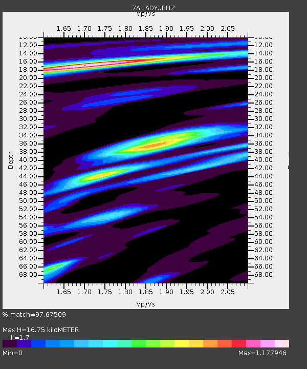
| Estimated Moho Depth: |
16.75 km |
| Estimated Crust Vp/Vs: |
1.70 |
| Assumed Crust Vp: |
6.159 km/s |
| Estimated Crust Vs: |
3.623 km/s |
| Estimated Crust Poisson's Ratio: |
0.24 |
|
| Radial Match: |
97.67509 % |
| Radial Bump: |
318 |
| Transverse Match: |
84.90164 % |
| Transverse Bump: |
400 |
| SOD ConfigId: |
3390531 |
| Insert Time: |
2019-04-10 16:53:34.310 +0000 |
| GWidth: |
2.5 |
| Max Bumps: |
400 |
| Tol: |
0.001 |
|

Signal To Noise
| Channel | StoN | STA | LTA |
| 7A:LADY: :BHZ:20140316T21:25:54.975017Z | 28.959513 | 5.4388524E-6 | 1.8780884E-7 |
| 7A:LADY: :BHN:20140316T21:25:54.975017Z | 16.543428 | 2.7048127E-6 | 1.6349772E-7 |
| 7A:LADY: :BHE:20140316T21:25:54.975017Z | 1.5484138 | 3.0960317E-7 | 1.9994862E-7 |
| Arrivals |
| Ps | 2.0 SECOND |
| PpPs | 7.0 SECOND |
| PsPs/PpSs | 9.0 SECOND |


