You are here: Home > Network List > TA - USArray Transportable Network (new EarthScope stations) Stations List
> Station E04D Cinebar, WA, USA > Earthquake Result Viewer
E04D Cinebar, WA, USA - Earthquake Result Viewer
| Earthquake location: |
Loyalty Islands |
| Earthquake latitude/longitude: |
-20.2/168.2 |
| Earthquake time(UTC): |
2011/05/10 (130) 08:55:08 GMT |
| Earthquake Depth: |
11 km |
| Earthquake Magnitude: |
6.4 MB, 6.8 MS, 6.9 MW, 6.8 MW |
| Earthquake Catalog/Contributor: |
WHDF/NEIC |
|
| Network: |
TA USArray Transportable Network (new EarthScope stations) |
| Station: |
E04D Cinebar, WA, USA |
| Lat/Lon: |
46.56 N/122.57 W |
| Elevation: |
204 m |
|
| Distance: |
91.1 deg |
| Az: |
40.184 deg |
| Baz: |
241.399 deg |
| Ray Param: |
0.0416271 |
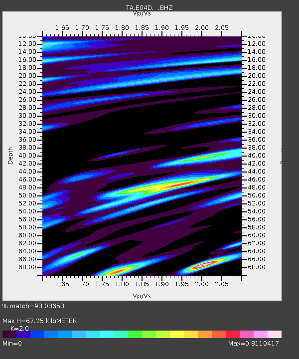
| Estimated Moho Depth: |
67.25 km |
| Estimated Crust Vp/Vs: |
2.00 |
| Assumed Crust Vp: |
6.566 km/s |
| Estimated Crust Vs: |
3.283 km/s |
| Estimated Crust Poisson's Ratio: |
0.33 |
|
| Radial Match: |
93.08653 % |
| Radial Bump: |
400 |
| Transverse Match: |
86.56463 % |
| Transverse Bump: |
400 |
| SOD ConfigId: |
390285 |
| Insert Time: |
2011-10-18 06:58:00.169 +0000 |
| GWidth: |
2.5 |
| Max Bumps: |
400 |
| Tol: |
0.001 |
|
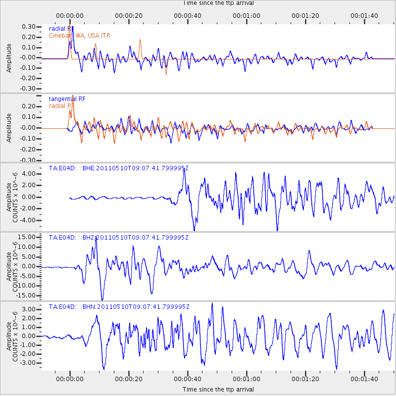
Signal To Noise
| Channel | StoN | STA | LTA |
| TA:E04D: :BHZ:20110510T09:07:41.799995Z | 19.594318 | 2.5001264E-6 | 1.2759446E-7 |
| TA:E04D: :BHN:20110510T09:07:41.799995Z | 1.7078727 | 1.623316E-7 | 9.5048996E-8 |
| TA:E04D: :BHE:20110510T09:07:41.799995Z | 2.0368552 | 2.973666E-7 | 1.45993E-7 |
| Arrivals |
| Ps | 10 SECOND |
| PpPs | 30 SECOND |
| PsPs/PpSs | 41 SECOND |


