You are here: Home > Network List > TA - USArray Transportable Network (new EarthScope stations) Stations List
> Station C06D Leavenworth, WQ, USA > Earthquake Result Viewer
C06D Leavenworth, WQ, USA - Earthquake Result Viewer
| Earthquake location: |
Loyalty Islands |
| Earthquake latitude/longitude: |
-20.2/168.2 |
| Earthquake time(UTC): |
2011/05/10 (130) 08:55:08 GMT |
| Earthquake Depth: |
11 km |
| Earthquake Magnitude: |
6.4 MB, 6.8 MS, 6.9 MW, 6.8 MW |
| Earthquake Catalog/Contributor: |
WHDF/NEIC |
|
| Network: |
TA USArray Transportable Network (new EarthScope stations) |
| Station: |
C06D Leavenworth, WQ, USA |
| Lat/Lon: |
47.92 N/120.89 W |
| Elevation: |
544 m |
|
| Distance: |
92.7 deg |
| Az: |
39.511 deg |
| Baz: |
242.646 deg |
| Ray Param: |
0.0413998 |
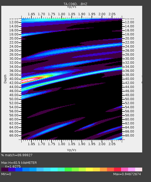
| Estimated Moho Depth: |
40.5 km |
| Estimated Crust Vp/Vs: |
1.63 |
| Assumed Crust Vp: |
6.597 km/s |
| Estimated Crust Vs: |
4.054 km/s |
| Estimated Crust Poisson's Ratio: |
0.20 |
|
| Radial Match: |
89.99927 % |
| Radial Bump: |
400 |
| Transverse Match: |
75.203865 % |
| Transverse Bump: |
400 |
| SOD ConfigId: |
390285 |
| Insert Time: |
2011-10-18 06:58:02.171 +0000 |
| GWidth: |
2.5 |
| Max Bumps: |
400 |
| Tol: |
0.001 |
|
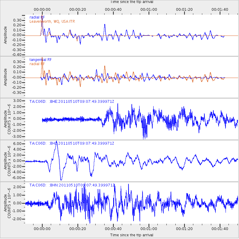
Signal To Noise
| Channel | StoN | STA | LTA |
| TA:C06D: :BHZ:20110510T09:07:49.399971Z | 13.768953 | 1.39089E-6 | 1.010164E-7 |
| TA:C06D: :BHN:20110510T09:07:49.399971Z | 1.7439988 | 2.9262736E-7 | 1.6779104E-7 |
| TA:C06D: :BHE:20110510T09:07:49.399971Z | 2.243985 | 4.145694E-7 | 1.8474697E-7 |
| Arrivals |
| Ps | 3.9 SECOND |
| PpPs | 16 SECOND |
| PsPs/PpSs | 20 SECOND |


