You are here: Home > Network List > US - United States National Seismic Network Stations List
> Station ELK Elko, Nevada, USA > Earthquake Result Viewer
ELK Elko, Nevada, USA - Earthquake Result Viewer
| Earthquake location: |
Loyalty Islands |
| Earthquake latitude/longitude: |
-20.2/168.2 |
| Earthquake time(UTC): |
2011/05/10 (130) 08:55:08 GMT |
| Earthquake Depth: |
11 km |
| Earthquake Magnitude: |
6.4 MB, 6.8 MS, 6.9 MW, 6.8 MW |
| Earthquake Catalog/Contributor: |
WHDF/NEIC |
|
| Network: |
US United States National Seismic Network |
| Station: |
ELK Elko, Nevada, USA |
| Lat/Lon: |
40.74 N/115.24 W |
| Elevation: |
2210 m |
|
| Distance: |
93.3 deg |
| Az: |
47.742 deg |
| Baz: |
246.161 deg |
| Ray Param: |
0.041288003 |
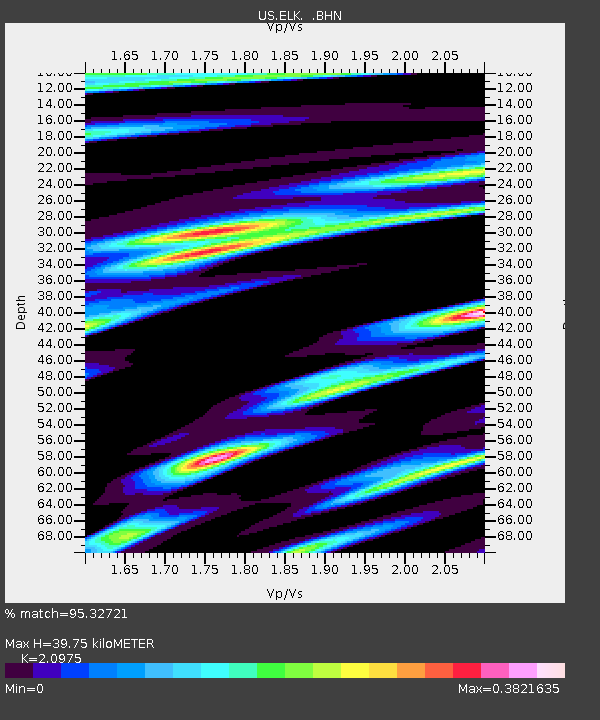
| Estimated Moho Depth: |
39.75 km |
| Estimated Crust Vp/Vs: |
2.10 |
| Assumed Crust Vp: |
6.276 km/s |
| Estimated Crust Vs: |
2.992 km/s |
| Estimated Crust Poisson's Ratio: |
0.35 |
|
| Radial Match: |
95.32721 % |
| Radial Bump: |
400 |
| Transverse Match: |
92.608086 % |
| Transverse Bump: |
400 |
| SOD ConfigId: |
390285 |
| Insert Time: |
2011-10-18 06:59:08.482 +0000 |
| GWidth: |
2.5 |
| Max Bumps: |
400 |
| Tol: |
0.001 |
|

Signal To Noise
| Channel | StoN | STA | LTA |
| US:ELK: :BHZ:20110510T09:07:51.989998Z | 12.873409 | 7.1402957E-7 | 5.546546E-8 |
| US:ELK: :BHN:20110510T09:07:51.989998Z | 2.228875 | 9.056638E-8 | 4.0633225E-8 |
| US:ELK: :BHE:20110510T09:07:51.989998Z | 3.2346761 | 1.1896567E-7 | 3.6778232E-8 |
| Arrivals |
| Ps | 7.1 SECOND |
| PpPs | 19 SECOND |
| PsPs/PpSs | 26 SECOND |


