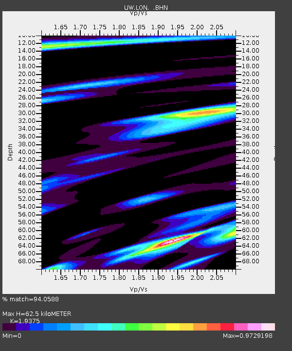
LON Longmire (broad-band and DWWSSN) - Earthquake Result Viewer
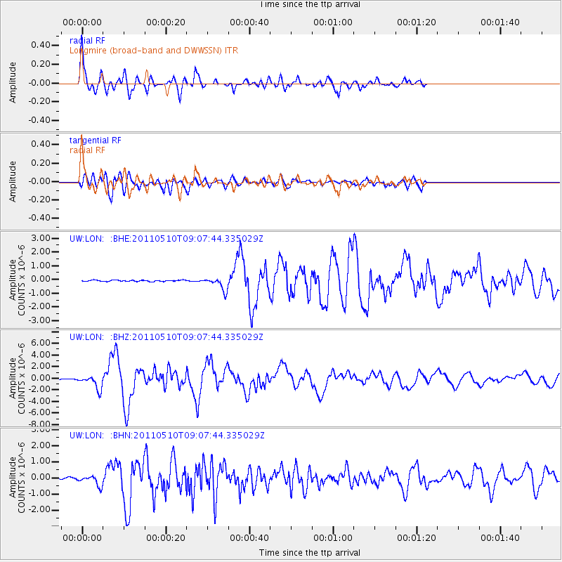
Earthquake location: Loyalty Islands
Earthquake latitude/longitude: -20.2/168.2
Earthquake time(UTC): 2011/05/10 (130) 08:55:08 GMT
Earthquake Depth: 11 km
Earthquake Magnitude: 6.4 MB, 6.8 MS, 6.9 MW, 6.8 MW
Earthquake Catalog/Contributor: WHDF/NEIC
Network: UW Pacific Northwest Regional Seismic Network
Station: LON Longmire (broad-band and DWWSSN)
Lat/Lon: 46.75 N/121.81 W
Elevation: 850 m
Distance: 91.6 deg
Az: 40.261 deg
Baz: 241.946 deg
Ray Param: 0.041579474
Estimated Moho Depth: 62.5 km
Estimated Crust Vp/Vs: 1.94
Assumed Crust Vp: 6.597 km/s
Estimated Crust Vs: 3.405 km/s
Estimated Crust Poisson's Ratio: 0.32
Radial Match: 94.0588 %
Radial Bump: 400
Transverse Match: 74.697296 %
Transverse Bump: 400
SOD ConfigId: 390285
Insert Time: 2011-10-18 06:59:38.641 +0000
GWidth: 2.5
Max Bumps: 400
Tol: 0.001

Signal To Noise

ChannelStoNSTALTA
UW:LON: :BHZ:20110510T09:07:44.335029Z23.1992381.2176492E-65.2486605E-8
UW:LON: :BHN:20110510T09:07:44.335029Z4.79506063.3004704E-76.883063E-8
UW:LON: :BHE:20110510T09:07:44.335029Z10.3840554.869608E-74.6895053E-8
Arrivals
Ps9.1 SECOND
PpPs27 SECOND
PsPs/PpSs36 SECOND