You are here: Home > Network List > UW - Pacific Northwest Regional Seismic Network Stations List
> Station FISH Seaside, OR, USA > Earthquake Result Viewer
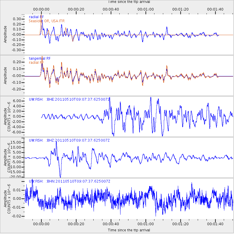
FISH Seaside, OR, USA - Earthquake Result Viewer
*The percent match for this event was below the threshold and hence no stack was calculated.
| Earthquake location: |
Loyalty Islands |
| Earthquake latitude/longitude: |
-20.2/168.2 |
| Earthquake time(UTC): |
2011/05/10 (130) 08:55:08 GMT |
| Earthquake Depth: |
11 km |
| Earthquake Magnitude: |
6.4 MB, 6.8 MS, 6.9 MW, 6.8 MW |
| Earthquake Catalog/Contributor: |
WHDF/NEIC |
|
| Network: |
UW Pacific Northwest Regional Seismic Network |
| Station: |
FISH Seaside, OR, USA |
| Lat/Lon: |
45.93 N/123.56 W |
| Elevation: |
325 m |
|
| Distance: |
90.2 deg |
| Az: |
40.398 deg |
| Baz: |
240.683 deg |
| Ray Param: |
$rayparam |
*The percent match for this event was below the threshold and hence was not used in the summary stack. |
|
| Radial Match: |
89.53547 % |
| Radial Bump: |
400 |
| Transverse Match: |
89.53325 % |
| Transverse Bump: |
400 |
| SOD ConfigId: |
390285 |
| Insert Time: |
2011-10-18 07:00:32.076 +0000 |
| GWidth: |
2.5 |
| Max Bumps: |
400 |
| Tol: |
0.001 |
|
Signal To Noise
| Channel | StoN | STA | LTA |
| UW:FISH: :BHZ:20110510T09:07:37.625007Z | 9.207451 | 2.7691547E-6 | 3.0075148E-7 |
| UW:FISH: :BHN:20110510T09:07:37.625007Z | 1.1442086 | 7.5416855E-9 | 6.5911805E-9 |
| UW:FISH: :BHE:20110510T09:07:37.625007Z | 1.3530041 | 7.5303154E-7 | 5.5656267E-7 |
| Arrivals |
| Ps | |
| PpPs | |
| PsPs/PpSs | |


