You are here: Home > Network List > TA - USArray Transportable Network (new EarthScope stations) Stations List
> Station N02D Trinity Center, CA, USA > Earthquake Result Viewer
N02D Trinity Center, CA, USA - Earthquake Result Viewer

| Earthquake location: |
Loyalty Islands |
| Earthquake latitude/longitude: |
-20.3/168.5 |
| Earthquake time(UTC): |
2011/05/10 (130) 10:44:07 GMT |
| Earthquake Depth: |
10 km |
| Earthquake Magnitude: |
5.5 MB |
| Earthquake Catalog/Contributor: |
WHDF/NEIC |
|
| Network: |
TA USArray Transportable Network (new EarthScope stations) |
| Station: |
N02D Trinity Center, CA, USA |
| Lat/Lon: |
40.97 N/122.71 W |
| Elevation: |
937 m |
|
| Distance: |
88.2 deg |
| Az: |
44.95 deg |
| Baz: |
241.133 deg |
| Ray Param: |
0.042749763 |
| Estimated Moho Depth: |
64.25 km |
| Estimated Crust Vp/Vs: |
1.94 |
| Assumed Crust Vp: |
6.566 km/s |
| Estimated Crust Vs: |
3.389 km/s |
| Estimated Crust Poisson's Ratio: |
0.32 |
|
| Radial Match: |
89.51159 % |
| Radial Bump: |
367 |
| Transverse Match: |
75.20814 % |
| Transverse Bump: |
400 |
| SOD ConfigId: |
390285 |
| Insert Time: |
2011-10-18 07:20:26.881 +0000 |
| GWidth: |
2.5 |
| Max Bumps: |
400 |
| Tol: |
0.001 |
|
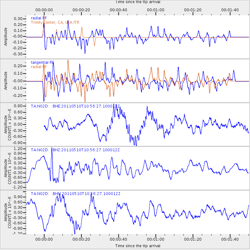
Signal To Noise
| Channel | StoN | STA | LTA |
| TA:N02D: :BHZ:20110510T10:56:27.100012Z | 1.2963786 | 6.642334E-7 | 5.123761E-7 |
| TA:N02D: :BHN:20110510T10:56:27.100012Z | 1.4074113 | 6.39136E-7 | 4.5412168E-7 |
| TA:N02D: :BHE:20110510T10:56:27.100012Z | 3.0719302 | 6.186178E-7 | 2.0137753E-7 |
| Arrivals |
| Ps | 9.4 SECOND |
| PpPs | 28 SECOND |
| PsPs/PpSs | 38 SECOND |


