You are here: Home > Network List > TA - USArray Transportable Network (new EarthScope stations) Stations List
> Station E62A Clayton Lake, ME, USA > Earthquake Result Viewer
E62A Clayton Lake, ME, USA - Earthquake Result Viewer
| Earthquake location: |
Near Coast Of Northern Chile |
| Earthquake latitude/longitude: |
-19.9/-70.6 |
| Earthquake time(UTC): |
2014/03/16 (075) 21:16:30 GMT |
| Earthquake Depth: |
20 km |
| Earthquake Magnitude: |
6.7 MWW, 6.7 MWC, 7.0 MI |
| Earthquake Catalog/Contributor: |
NEIC PDE/NEIC COMCAT |
|
| Network: |
TA USArray Transportable Network (new EarthScope stations) |
| Station: |
E62A Clayton Lake, ME, USA |
| Lat/Lon: |
46.62 N/69.52 W |
| Elevation: |
356 m |
|
| Distance: |
66.2 deg |
| Az: |
0.832 deg |
| Baz: |
181.136 deg |
| Ray Param: |
0.057726797 |
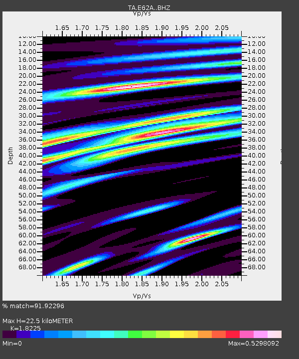
| Estimated Moho Depth: |
22.5 km |
| Estimated Crust Vp/Vs: |
1.82 |
| Assumed Crust Vp: |
6.419 km/s |
| Estimated Crust Vs: |
3.522 km/s |
| Estimated Crust Poisson's Ratio: |
0.28 |
|
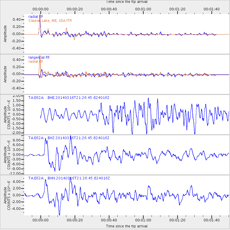
| Radial Match: |
91.92296 % |
| Radial Bump: |
391 |
| Transverse Match: |
76.222664 % |
| Transverse Bump: |
400 |
| SOD ConfigId: |
3390531 |
| Insert Time: |
2019-04-10 16:57:08.794 +0000 |
| GWidth: |
2.5 |
| Max Bumps: |
400 |
| Tol: |
0.001 |
|
Signal To Noise
| Channel | StoN | STA | LTA |
| TA:E62A: :BHZ:20140316T21:26:45.824016Z | 8.870135 | 4.844276E-6 | 5.4613326E-7 |
| TA:E62A: :BHN:20140316T21:26:45.824016Z | 6.562794 | 2.0499183E-6 | 3.123545E-7 |
| TA:E62A: :BHE:20140316T21:26:45.824016Z | 0.93853647 | 3.5540555E-7 | 3.786806E-7 |
| Arrivals |
| Ps | 3.0 SECOND |
| PpPs | 9.5 SECOND |
| PsPs/PpSs | 13 SECOND |


