You are here: Home > Network List > CI - Caltech Regional Seismic Network Stations List
> Station MPM Manuel Prospect Mine, California, USA > Earthquake Result Viewer
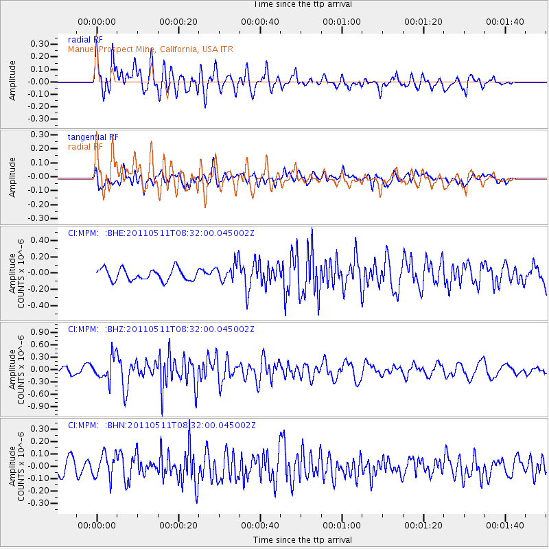
MPM Manuel Prospect Mine, California, USA - Earthquake Result Viewer
*The percent match for this event was below the threshold and hence no stack was calculated.
| Earthquake location: |
Loyalty Islands |
| Earthquake latitude/longitude: |
-20.3/168.3 |
| Earthquake time(UTC): |
2011/05/11 (131) 08:19:33 GMT |
| Earthquake Depth: |
10 km |
| Earthquake Magnitude: |
5.8 MB, 5.2 MS, 5.6 MW, 5.6 MW |
| Earthquake Catalog/Contributor: |
WHDF/NEIC |
|
| Network: |
CI Caltech Regional Seismic Network |
| Station: |
MPM Manuel Prospect Mine, California, USA |
| Lat/Lon: |
36.06 N/117.49 W |
| Elevation: |
185 m |
|
| Distance: |
89.7 deg |
| Az: |
51.219 deg |
| Baz: |
244.56 deg |
| Ray Param: |
$rayparam |
*The percent match for this event was below the threshold and hence was not used in the summary stack. |
|
| Radial Match: |
76.51509 % |
| Radial Bump: |
400 |
| Transverse Match: |
48.31382 % |
| Transverse Bump: |
400 |
| SOD ConfigId: |
390285 |
| Insert Time: |
2011-10-18 07:36:19.648 +0000 |
| GWidth: |
2.5 |
| Max Bumps: |
400 |
| Tol: |
0.001 |
|
Signal To Noise
| Channel | StoN | STA | LTA |
| CI:MPM: :BHZ:20110511T08:32:00.045002Z | 3.2513452 | 2.8314818E-7 | 8.708647E-8 |
| CI:MPM: :BHN:20110511T08:32:00.045002Z | 1.8431811 | 1.0120544E-7 | 5.4908025E-8 |
| CI:MPM: :BHE:20110511T08:32:00.045002Z | 1.6624869 | 1.18516176E-7 | 7.128849E-8 |
| Arrivals |
| Ps | |
| PpPs | |
| PsPs/PpSs | |


