You are here: Home > Network List > TA - USArray Transportable Network (new EarthScope stations) Stations List
> Station R11A Troy Canyon, Currant, NV, USA > Earthquake Result Viewer
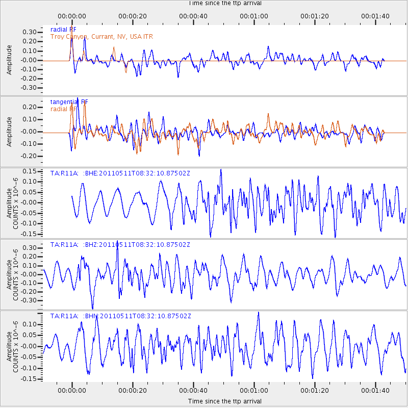
R11A Troy Canyon, Currant, NV, USA - Earthquake Result Viewer
*The percent match for this event was below the threshold and hence no stack was calculated.
| Earthquake location: |
Loyalty Islands |
| Earthquake latitude/longitude: |
-20.3/168.3 |
| Earthquake time(UTC): |
2011/05/11 (131) 08:19:33 GMT |
| Earthquake Depth: |
10 km |
| Earthquake Magnitude: |
5.8 MB, 5.2 MS, 5.6 MW, 5.6 MW |
| Earthquake Catalog/Contributor: |
WHDF/NEIC |
|
| Network: |
TA USArray Transportable Network (new EarthScope stations) |
| Station: |
R11A Troy Canyon, Currant, NV, USA |
| Lat/Lon: |
38.35 N/115.59 W |
| Elevation: |
1756 m |
|
| Distance: |
92.0 deg |
| Az: |
49.783 deg |
| Baz: |
245.728 deg |
| Ray Param: |
$rayparam |
*The percent match for this event was below the threshold and hence was not used in the summary stack. |
|
| Radial Match: |
62.295 % |
| Radial Bump: |
400 |
| Transverse Match: |
64.54487 % |
| Transverse Bump: |
400 |
| SOD ConfigId: |
390285 |
| Insert Time: |
2011-10-18 07:42:10.848 +0000 |
| GWidth: |
2.5 |
| Max Bumps: |
400 |
| Tol: |
0.001 |
|
Signal To Noise
| Channel | StoN | STA | LTA |
| TA:R11A: :BHZ:20110511T08:32:10.87502Z | 2.1847188 | 1.2225688E-7 | 5.5960008E-8 |
| TA:R11A: :BHN:20110511T08:32:10.87502Z | 1.515831 | 6.288322E-8 | 4.148432E-8 |
| TA:R11A: :BHE:20110511T08:32:10.87502Z | 1.3920463 | 6.541904E-8 | 4.699487E-8 |
| Arrivals |
| Ps | |
| PpPs | |
| PsPs/PpSs | |


