You are here: Home > Network List > X812 - Deep Structure of Three Continental Sutures in Eastern North America Stations List
> Station QM66 Explorers Mine, Chibougamau, Quebec, Canada > Earthquake Result Viewer
QM66 Explorers Mine, Chibougamau, Quebec, Canada - Earthquake Result Viewer
| Earthquake location: |
Near Coast Of Northern Chile |
| Earthquake latitude/longitude: |
-19.9/-70.6 |
| Earthquake time(UTC): |
2014/03/16 (075) 21:16:30 GMT |
| Earthquake Depth: |
20 km |
| Earthquake Magnitude: |
6.7 MWW, 6.7 MWC, 7.0 MI |
| Earthquake Catalog/Contributor: |
NEIC PDE/NEIC COMCAT |
|
| Network: |
X8 Deep Structure of Three Continental Sutures in Eastern North America |
| Station: |
QM66 Explorers Mine, Chibougamau, Quebec, Canada |
| Lat/Lon: |
49.49 N/74.44 W |
| Elevation: |
405 m |
|
| Distance: |
69.2 deg |
| Az: |
357.343 deg |
| Baz: |
176.166 deg |
| Ray Param: |
0.055796497 |
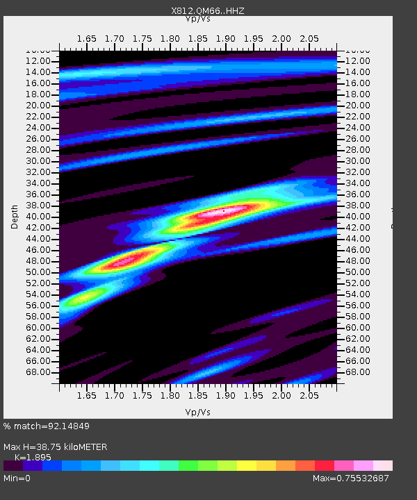
| Estimated Moho Depth: |
38.75 km |
| Estimated Crust Vp/Vs: |
1.89 |
| Assumed Crust Vp: |
6.61 km/s |
| Estimated Crust Vs: |
3.488 km/s |
| Estimated Crust Poisson's Ratio: |
0.31 |
|
| Radial Match: |
92.14849 % |
| Radial Bump: |
284 |
| Transverse Match: |
55.799713 % |
| Transverse Bump: |
400 |
| SOD ConfigId: |
3390531 |
| Insert Time: |
2019-04-10 16:58:37.111 +0000 |
| GWidth: |
2.5 |
| Max Bumps: |
400 |
| Tol: |
0.001 |
|

Signal To Noise
| Channel | StoN | STA | LTA |
| X8:QM66: :HHZ:20140316T21:27:04.360027Z | 11.344429 | 3.8304674E-6 | 3.3765187E-7 |
| X8:QM66: :HHN:20140316T21:27:04.360027Z | 4.435362 | 1.4442026E-6 | 3.2561098E-7 |
| X8:QM66: :HHE:20140316T21:27:04.360027Z | 1.5226985 | 5.805922E-7 | 3.812916E-7 |
| Arrivals |
| Ps | 5.4 SECOND |
| PpPs | 16 SECOND |
| PsPs/PpSs | 22 SECOND |


