You are here: Home > Network List > UW - Pacific Northwest Regional Seismic Network Stations List
> Station LEBA Lebam, WA, USA > Earthquake Result Viewer
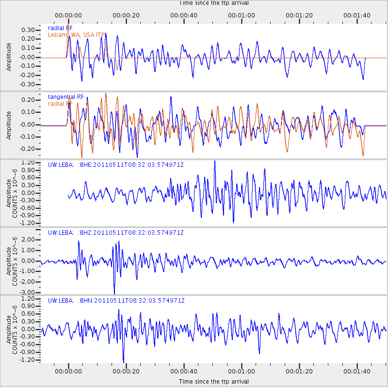
LEBA Lebam, WA, USA - Earthquake Result Viewer
*The percent match for this event was below the threshold and hence no stack was calculated.
| Earthquake location: |
Loyalty Islands |
| Earthquake latitude/longitude: |
-20.3/168.3 |
| Earthquake time(UTC): |
2011/05/11 (131) 08:19:33 GMT |
| Earthquake Depth: |
10 km |
| Earthquake Magnitude: |
5.8 MB, 5.2 MS, 5.6 MW, 5.6 MW |
| Earthquake Catalog/Contributor: |
WHDF/NEIC |
|
| Network: |
UW Pacific Northwest Regional Seismic Network |
| Station: |
LEBA Lebam, WA, USA |
| Lat/Lon: |
46.55 N/123.56 W |
| Elevation: |
73 m |
|
| Distance: |
90.4 deg |
| Az: |
39.819 deg |
| Baz: |
240.56 deg |
| Ray Param: |
$rayparam |
*The percent match for this event was below the threshold and hence was not used in the summary stack. |
|
| Radial Match: |
77.52962 % |
| Radial Bump: |
400 |
| Transverse Match: |
66.09557 % |
| Transverse Bump: |
400 |
| SOD ConfigId: |
390285 |
| Insert Time: |
2011-10-18 07:46:41.463 +0000 |
| GWidth: |
2.5 |
| Max Bumps: |
400 |
| Tol: |
0.001 |
|
Signal To Noise
| Channel | StoN | STA | LTA |
| UW:LEBA: :BHZ:20110511T08:32:03.574971Z | 5.834217 | 6.6021863E-7 | 1.1316319E-7 |
| UW:LEBA: :BHN:20110511T08:32:03.574971Z | 1.4749725 | 2.109164E-7 | 1.4299684E-7 |
| UW:LEBA: :BHE:20110511T08:32:03.574971Z | 0.9933799 | 1.7044863E-7 | 1.7158455E-7 |
| Arrivals |
| Ps | |
| PpPs | |
| PsPs/PpSs | |


