You are here: Home > Network List > CI - Caltech Regional Seismic Network Stations List
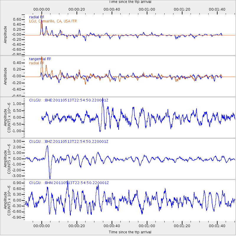
> Station LGU LGU, Camarillo, CA, USA > Earthquake Result Viewer
LGU LGU, Camarillo, CA, USA - Earthquake Result Viewer
| Earthquake location: |
Costa Rica |
| Earthquake latitude/longitude: |
10.0/-84.3 |
| Earthquake time(UTC): |
2011/05/13 (133) 22:47:54 GMT |
| Earthquake Depth: |
73 km |
| Earthquake Magnitude: |
5.6 MB, 5.9 MW, 6.0 MW |
| Earthquake Catalog/Contributor: |
WHDF/NEIC |
|
| Network: |
CI Caltech Regional Seismic Network |
| Station: |
LGU LGU, Camarillo, CA, USA |
| Lat/Lon: |
34.11 N/119.07 W |
| Elevation: |
416 m |
|
| Distance: |
39.9 deg |
| Az: |
312.461 deg |
| Baz: |
118.845 deg |
| Ray Param: |
0.0745014 |
| Estimated Moho Depth: |
61.0 km |
| Estimated Crust Vp/Vs: |
2.02 |
| Assumed Crust Vp: |
6.1 km/s |
| Estimated Crust Vs: |
3.027 km/s |
| Estimated Crust Poisson's Ratio: |
0.34 |
|
| Radial Match: |
83.402176 % |
| Radial Bump: |
400 |
| Transverse Match: |
75.49656 % |
| Transverse Bump: |
400 |
| SOD ConfigId: |
390285 |
| Insert Time: |
2011-10-18 08:01:33.049 +0000 |
| GWidth: |
2.5 |
| Max Bumps: |
400 |
| Tol: |
0.001 |
|
Signal To Noise
| Channel | StoN | STA | LTA |
| CI:LGU: :BHZ:20110513T22:54:50.220001Z | 8.521116 | 1.4214659E-6 | 1.6681686E-7 |
| CI:LGU: :BHN:20110513T22:54:50.220001Z | 2.0234194 | 3.419253E-7 | 1.689839E-7 |
| CI:LGU: :BHE:20110513T22:54:50.220001Z | 2.9866831 | 5.5077544E-7 | 1.8441041E-7 |
| Arrivals |
| Ps | 11 SECOND |
| PpPs | 29 SECOND |
| PsPs/PpSs | 39 SECOND |


