You are here: Home > Network List > NE - New England Seismic Network Stations List
> Station FFD Franklin Falls Dam, NH > Earthquake Result Viewer
FFD Franklin Falls Dam, NH - Earthquake Result Viewer
| Earthquake location: |
Costa Rica |
| Earthquake latitude/longitude: |
10.0/-84.3 |
| Earthquake time(UTC): |
2011/05/13 (133) 22:47:54 GMT |
| Earthquake Depth: |
73 km |
| Earthquake Magnitude: |
5.6 MB, 5.9 MW, 6.0 MW |
| Earthquake Catalog/Contributor: |
WHDF/NEIC |
|
| Network: |
NE New England Seismic Network |
| Station: |
FFD Franklin Falls Dam, NH |
| Lat/Lon: |
43.47 N/71.65 W |
| Elevation: |
131 m |
|
| Distance: |
35.2 deg |
| Az: |
16.084 deg |
| Baz: |
202.017 deg |
| Ray Param: |
0.07715651 |
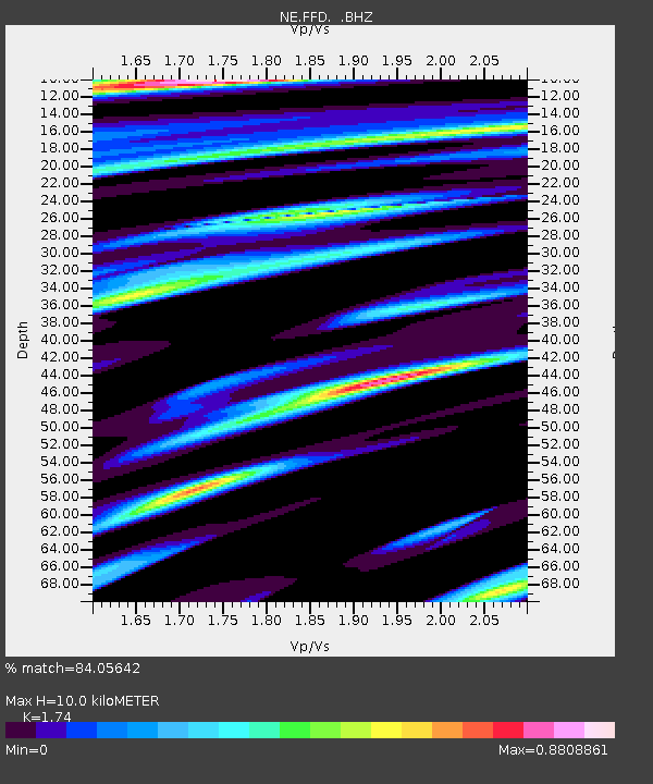
| Estimated Moho Depth: |
10.0 km |
| Estimated Crust Vp/Vs: |
1.74 |
| Assumed Crust Vp: |
6.419 km/s |
| Estimated Crust Vs: |
3.689 km/s |
| Estimated Crust Poisson's Ratio: |
0.25 |
|
| Radial Match: |
84.05642 % |
| Radial Bump: |
400 |
| Transverse Match: |
54.411865 % |
| Transverse Bump: |
400 |
| SOD ConfigId: |
390285 |
| Insert Time: |
2011-10-18 08:09:54.189 +0000 |
| GWidth: |
2.5 |
| Max Bumps: |
400 |
| Tol: |
0.001 |
|

Signal To Noise
| Channel | StoN | STA | LTA |
| NE:FFD: :BHZ:20110513T22:54:10.519989Z | 4.5881515 | 1.9982306E-6 | 4.3551975E-7 |
| NE:FFD: :BHN:20110513T22:54:10.519989Z | 3.4660993 | 1.234374E-6 | 3.561277E-7 |
| NE:FFD: :BHE:20110513T22:54:10.519989Z | 1.3488662 | 7.935621E-7 | 5.8831785E-7 |
| Arrivals |
| Ps | 1.2 SECOND |
| PpPs | 4.0 SECOND |
| PsPs/PpSs | 5.2 SECOND |


