You are here: Home > Network List > TA - USArray Transportable Network (new EarthScope stations) Stations List
> Station G25A Newell, SD, USA > Earthquake Result Viewer
G25A Newell, SD, USA - Earthquake Result Viewer

| Earthquake location: |
Costa Rica |
| Earthquake latitude/longitude: |
10.0/-84.3 |
| Earthquake time(UTC): |
2011/05/13 (133) 22:47:54 GMT |
| Earthquake Depth: |
73 km |
| Earthquake Magnitude: |
5.6 MB, 5.9 MW, 6.0 MW |
| Earthquake Catalog/Contributor: |
WHDF/NEIC |
|
| Network: |
TA USArray Transportable Network (new EarthScope stations) |
| Station: |
G25A Newell, SD, USA |
| Lat/Lon: |
45.19 N/103.42 W |
| Elevation: |
894 m |
|
| Distance: |
38.8 deg |
| Az: |
338.311 deg |
| Baz: |
149.01 deg |
| Ray Param: |
0.075148195 |
| Estimated Moho Depth: |
19.5 km |
| Estimated Crust Vp/Vs: |
1.60 |
| Assumed Crust Vp: |
6.242 km/s |
| Estimated Crust Vs: |
3.901 km/s |
| Estimated Crust Poisson's Ratio: |
0.18 |
|
| Radial Match: |
84.836464 % |
| Radial Bump: |
303 |
| Transverse Match: |
51.625443 % |
| Transverse Bump: |
387 |
| SOD ConfigId: |
390285 |
| Insert Time: |
2011-10-18 08:14:12.833 +0000 |
| GWidth: |
2.5 |
| Max Bumps: |
400 |
| Tol: |
0.001 |
|
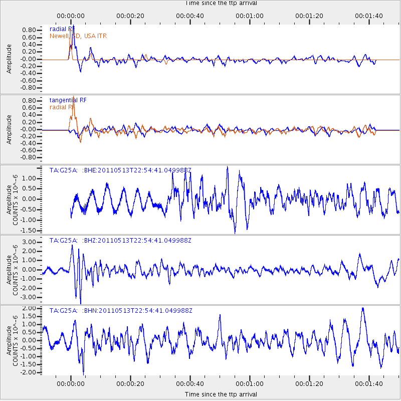
Signal To Noise
| Channel | StoN | STA | LTA |
| TA:G25A: :BHZ:20110513T22:54:41.049988Z | 10.243504 | 1.6877021E-6 | 1.6475829E-7 |
| TA:G25A: :BHN:20110513T22:54:41.049988Z | 2.0266902 | 8.720993E-7 | 4.3030715E-7 |
| TA:G25A: :BHE:20110513T22:54:41.049988Z | 1.1987411 | 4.7300736E-7 | 3.9458675E-7 |
| Arrivals |
| Ps | 2.0 SECOND |
| PpPs | 7.5 SECOND |
| PsPs/PpSs | 9.6 SECOND |


