You are here: Home > Network List > Z910 - Southeastern Suture of the Appalachian Margin Experiment Stations List
> Station D07 Ogden Property, Tignall, GA > Earthquake Result Viewer
D07 Ogden Property, Tignall, GA - Earthquake Result Viewer
| Earthquake location: |
Near Coast Of Northern Chile |
| Earthquake latitude/longitude: |
-19.9/-70.6 |
| Earthquake time(UTC): |
2014/03/16 (075) 21:16:30 GMT |
| Earthquake Depth: |
20 km |
| Earthquake Magnitude: |
6.7 MWW, 6.7 MWC, 7.0 MI |
| Earthquake Catalog/Contributor: |
NEIC PDE/NEIC COMCAT |
|
| Network: |
Z9 Southeastern Suture of the Appalachian Margin Experiment |
| Station: |
D07 Ogden Property, Tignall, GA |
| Lat/Lon: |
33.94 N/82.69 W |
| Elevation: |
140 m |
|
| Distance: |
54.8 deg |
| Az: |
347.725 deg |
| Baz: |
166.078 deg |
| Ray Param: |
0.06520579 |
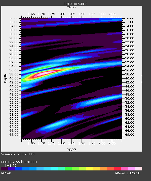
| Estimated Moho Depth: |
37.0 km |
| Estimated Crust Vp/Vs: |
1.72 |
| Assumed Crust Vp: |
6.565 km/s |
| Estimated Crust Vs: |
3.817 km/s |
| Estimated Crust Poisson's Ratio: |
0.24 |
|
| Radial Match: |
93.873116 % |
| Radial Bump: |
364 |
| Transverse Match: |
66.99529 % |
| Transverse Bump: |
400 |
| SOD ConfigId: |
3390531 |
| Insert Time: |
2019-04-10 17:00:44.958 +0000 |
| GWidth: |
2.5 |
| Max Bumps: |
400 |
| Tol: |
0.001 |
|

Signal To Noise
| Channel | StoN | STA | LTA |
| Z9:D07: :BHZ:20140316T21:25:27.75999Z | 14.529924 | 3.7497095E-6 | 2.5806807E-7 |
| Z9:D07: :BHN:20140316T21:25:27.75999Z | 12.70778 | 1.953629E-6 | 1.5373489E-7 |
| Z9:D07: :BHE:20140316T21:25:27.75999Z | 3.300684 | 4.1555163E-7 | 1.2589864E-7 |
| Arrivals |
| Ps | 4.3 SECOND |
| PpPs | 14 SECOND |
| PsPs/PpSs | 19 SECOND |


